Issued by the Storm Prediction Center
April 29, 2025
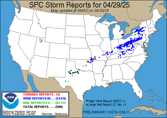
| STORM REPORTS Issued by the Storm Prediction Center |
| Select date for other reports |
April 29, 2025 |
|
| 599 reports sorted by the latest reports first |
| Apr 30 1:20 am CDT |
| TEXAS - Scurry COUNTY - 2 MILES NORTHWEST OF Hermleigh |
| HAIL - 1.75 in - (Midland/Odessa, TX) |
| Apr 30 1:10 am CDT |
| OKLAHOMA - Cherokee COUNTY - 4 MILES NORTH OF Tahlequah |
| WIND - 62 mph - (Tulsa, OK) |
| Apr 30 1:06 am CDT |
| TEXAS - Scurry COUNTY - 2 MILES SOUTH OF Snyder |
| HAIL - 1.00 in - (Midland/Odessa, TX) |
| Apr 30 12:42 am CDT |
| OKLAHOMA - Tillman COUNTY - 2 MILES SOUTH OF Hollister |
| HAIL - 1.00 in - (Oklahoma City, OK) |
| Apr 29 11:10 pm CDT |
| WEST VIRGINIA - Pocahontas COUNTY - 5 MILES WEST-NORTHWEST OF Marlinton |
| WIND - 1 tree down across Williams River Road. (Charleston, WV) |
| Apr 29 11:10 pm CDT |
| WEST VIRGINIA - Randolph COUNTY - 7 MILES WEST OF Harman |
| WIND - 2 trees down across Allegheny Highway. (Charleston, WV) |
| Apr 29 11:06 pm CDT |
| WEST VIRGINIA - Barbour COUNTY - 5 MILES WEST-NORTHWEST OF Philippi |
| WIND - Tree down across Stewart Run Road. (Charleston, WV) |
| Apr 29 10:51 pm CDT |
| WEST VIRGINIA - Barbour COUNTY - 4 MILES WEST-NORTHWEST OF Philippi |
| WIND - Tree down across Cherry Hill Road. (Charleston, WV) |
| Apr 29 10:37 pm CDT |
| WEST VIRGINIA - Randolph COUNTY - 3 MILES SOUTH OF Elkins |
| WIND - 63 mph - ASOS station KEKN Elkins Airport. (Charleston, WV) |
| Apr 29 10:30 pm CDT |
| WEST VIRGINIA - Barbour COUNTY - 1 MILE WEST OF Philippi |
| WIND - Tree down blocking Cherry Hill Rd. Time estimated by radar. (Charleston, WV) |
| Apr 29 10:20 pm CDT |
| WEST VIRGINIA - Upshur COUNTY - 3 MILES NORTHEAST OF Buckhannon |
| WIND - Tree down blocking both lanes of Hall Rd between Fishing Camp Rd and Macedonia Rd outside of Buckhannon. Time estimated by radar. (Charleston, WV) |
| Apr 29 10:16 pm CDT |
| WEST VIRGINIA - Upshur COUNTY - 5 MILES EAST-NORTHEAST OF Rock Cave |
| WIND - Power lines down 4000 block of Alton Rd. There is a small fire associated with the lines being down. Time estimated via radar. (Charleston, WV) |
| Apr 29 10:16 pm CDT |
| WEST VIRGINIA - Upshur COUNTY - 5 MILES WEST OF Buckhannon |
| WIND - Tree down blocking Sauls Run Rd near the 1030 block. Tree is estimated to be 20 feet long. Time estimated by radar. (Charleston, WV) |
| Apr 29 10:14 pm CDT |
| WEST VIRGINIA - Upshur COUNTY - 3 MILES WEST-SOUTHWEST OF Buckhannon |
| WIND - Upshur 911 reports a tree down on Stony Run Rd about a half a mile from Brushy Fork Rd. Time estimated via radar. (Charleston, WV) |
| Apr 29 10:14 pm CDT |
| WEST VIRGINIA - Harrison COUNTY - 2 MILES EAST-NORTHEAST OF Bridgeport |
| WIND - 58 mph - ASOS station KCKB Clarksburg Airport. (Charleston, WV) |
| Apr 29 10:10 pm CDT |
| WEST VIRGINIA - Nicholas COUNTY - 9 MILES WEST-SOUTHWEST OF Richwood |
| WIND - Two trees down across Rt 20. (Charleston, WV) |
| Apr 29 9:57 pm CDT |
| WEST VIRGINIA - Braxton COUNTY - Newville |
| WIND - Tree reported down in Newville. Time is estimated by radar. (Charleston, WV) |
| Apr 29 9:55 pm CDT |
| WEST VIRGINIA - Braxton COUNTY - Sutton |
| WIND - Tree reported down in Sutton. Time is estimated by radar. (Charleston, WV) |
| Apr 29 9:47 pm CDT |
| WEST VIRGINIA - Braxton COUNTY - Gassaway |
| WIND - Tree reported down in Gassaway. Time is estimated by radar. (Charleston, WV) |
| Apr 29 9:40 pm CDT |
| WEST VIRGINIA - Fayette COUNTY - 3 MILES SOUTHEAST OF Gauley Bridge |
| WIND - Large tree limb reported down on Route 60. Time is estimated by radar. (Charleston, WV) |
| Apr 29 9:28 pm CDT |
| WEST VIRGINIA - Fayette COUNTY - 5 MILES NORTH-NORTHWEST OF Gauley Bridge |
| WIND - Tree reported down blocking one lane of Cannelton Hollow Road. Time is estimated by radar. (Charleston, WV) |
| Apr 29 9:16 pm CDT |
| TEXAS - Young COUNTY - 6 MILES NORTHEAST OF Elbert |
| HAIL - 1.25 in - Report from mPING: Half Dollar (1.25 in.). (Dallas/Fort Worth, TX) |
| Apr 29 9:16 pm CDT |
| TEXAS - Young COUNTY - 6 MILES SOUTH OF Megargel |
| HAIL - 2.00 in - Report from mPING: Hen Egg (2.00 in.). (Dallas/Fort Worth, TX) |
| Apr 29 9:00 pm CDT |
| WEST VIRGINIA - Kanawha COUNTY - 3 MILES WEST OF Pinch |
| WIND - Tree reported down. (Charleston, WV) |
| Apr 29 9:00 pm CDT |
| WEST VIRGINIA - Kanawha COUNTY - 4 MILES WEST-SOUTHWEST OF Clendenin |
| WIND - Downed tree reported on Elk River Road near Falling Rock. Time estimated from radar. (Charleston, WV) |
| Apr 29 9:00 pm CDT |
| WEST VIRGINIA - Kanawha COUNTY - 3 MILES NORTHEAST OF Elkview |
| WIND - Downed tree reported on Elk River Road at Hayes Street. Time estimated from radar. (Charleston, WV) |
| Apr 29 9:00 pm CDT |
| WEST VIRGINIA - Ritchie COUNTY - 2 MILES NORTHWEST OF Cairo |
| WIND - Downed tree reported on Shields Hill Road between Long Run and Big Run. Time estimated from radar. (Charleston, WV) |
| Apr 29 8:59 pm CDT |
| WEST VIRGINIA - Kanawha COUNTY - 5 MILES EAST OF Coal Fork |
| WIND - Tree damage resulting in 432 customers without power. (Charleston, WV) |
| Apr 29 8:57 pm CDT |
| WEST VIRGINIA - Wood COUNTY - 5 MILES EAST OF North Hills |
| WIND - Power lines down 900 block of Deerwalk Highway. Time estimated by radar. (Charleston, WV) |
| Apr 29 8:55 pm CDT |
| WEST VIRGINIA - Kanawha COUNTY - Dunbar |
| WIND - Downed tree reported near the Interstate 64 eastbound entrance ramp. (Charleston, WV) |
| Apr 29 8:48 pm CDT |
| WEST VIRGINIA - Kanawha COUNTY - 1 MILE SOUTHEAST OF Saint Albans |
| WIND - Downed tree reported on Sunset Drive. (Charleston, WV) |
| Apr 29 8:44 pm CDT |
| WEST VIRGINIA - Putnam COUNTY - Hurricane |
| WIND - Tree down on home near Valley View Drive. (Charleston, WV) |
| Apr 29 8:38 pm CDT |
| WEST VIRGINIA - Putnam COUNTY - 2 MILES SOUTH-SOUTHEAST OF Hurricane |
| WIND - Tree down blocking half the road in the 40 block of Stuart Circle in Hurricane. Time estimated via radar. (Charleston, WV) |
| Apr 29 8:36 pm CDT |
| WEST VIRGINIA - Putnam COUNTY - 2 MILES SOUTH-SOUTHWEST OF Hurricane |
| WIND - Putnam County 911 center reports a large oak tree down on Lower Coach Rd in Hurricane and fell on a power pole causing power outage in the area. Time estimated by radar (Charleston, WV) |
| Apr 29 8:31 pm CDT |
| OHIO - Athens COUNTY - 4 MILES SOUTH OF Amesville |
| WIND - Tree down across Mush Run Road. (Charleston, WV) |
| Apr 29 8:30 pm CDT |
| WEST VIRGINIA - Kanawha COUNTY - 3 MILES WEST OF Saint Albans |
| WIND - Downed trees and lines reported along Coal River Road and Strawberry Road between Saint Albans and Tornado. Time estimated from radar. (Charleston, WV) |
| Apr 29 8:30 pm CDT |
| WEST VIRGINIA - Kanawha COUNTY - 1 MILE EAST-SOUTHEAST OF Nitro |
| WIND - Downed tree reported on Robin Road. Time estimated from radar. (Charleston, WV) |
| Apr 29 8:25 pm CDT |
| KENTUCKY - Breathitt COUNTY - 1 MILE WEST OF Morris Fork |
| WIND - Social media report of a small tree down on a barn near the end of Freeman Fork Road in extreme SW Breathitt County. Time estimated via radar. (Jackson, KY) |
| Apr 29 8:25 pm CDT |
| WEST VIRGINIA - Putnam COUNTY - 5 MILES WEST-NORTHWEST OF Tornado |
| WIND - Downed tree reported on Martins Branch Road. Time estimated from radar. (Charleston, WV) |
| Apr 29 8:23 pm CDT |
| TEXAS - Wichita COUNTY - Burkburnett |
| WIND - 70 mph - (Oklahoma City, OK) |
| Apr 29 8:22 pm CDT |
| KENTUCKY - Wayne COUNTY - 1 MILE EAST-SOUTHEAST OF Monticello |
| WIND - Wayne County 911 reports trees downed on Dugan Street in Monticello. Time estimated via radar. (Jackson, KY) |
| Apr 29 8:20 pm CDT |
| OHIO - Athens COUNTY - 1 MILE SOUTHWEST OF Buchtel |
| WIND - Downed tree and lines off Happy Hollow Road. (Charleston, WV) |
| Apr 29 8:12 pm CDT |
| OHIO - Athens COUNTY - 4 MILES NORTH-NORTHEAST OF Albany |
| WIND - Downed tree on transformer reported on Selby Road. (Charleston, WV) |
| Apr 29 8:10 pm CDT |
| KENTUCKY - Owsley COUNTY - Vincent |
| WIND - Social media report of a tree down near the old Vincent Post Office... time estimated via radar. (Jackson, KY) |
| Apr 29 8:09 pm CDT |
| KENTUCKY - Magoffin COUNTY - 1 MILE SOUTH OF Gullett |
| WIND - A tree was reported to have been downed and blocking Down and Around Road off of KY 30 and also south of Exit 70 along the Mountain Parkway. The event time is radar est (Jackson, KY) |
| Apr 29 7:56 pm CDT |
| WEST VIRGINIA - Wayne COUNTY - 7 MILES NORTH OF Fort Gay |
| WIND - Tree down in the road 13800 block of route 52 south of Prichard. Time estimated by radar. (Charleston, WV) |
| Apr 29 7:47 pm CDT |
| KENTUCKY - Breathitt COUNTY - 1 MILE SOUTH OF Fivemile |
| WIND - Social media report of a tree down on Privett Lane in the Wolverine area of Breathitt Count. Time estimated via radar. (Jackson, KY) |
| Apr 29 7:44 pm CDT |
| KENTUCKY - Jackson COUNTY - 1 MILE SOUTH OF Foxtown |
| WIND - Jackson County 911 Center reported a tree down near the 580 Block of Brushy Ridge Rd. Time estimate from radar. (Jackson, KY) |
| Apr 29 7:31 pm CDT |
| TEXAS - Baylor COUNTY - 5 MILES SOUTHWEST OF Dundee |
| HAIL - 1.00 in - Report from mPING: Quarter (1.00 in.). (Oklahoma City, OK) |
| Apr 29 7:30 pm CDT |
| KENTUCKY - Casey COUNTY - 2 MILES NORTHEAST OF Liberty |
| WIND - Tree down on US 127 blocking part of the hwy near the Casey County Board of Education. (Louisville, KY) |
| Apr 29 7:24 pm CDT |
| PENNSYLVANIA - Wyoming COUNTY - Tunkhannock |
| WIND - Railroad gate knocked over from wind. Time estimated from radar. (Binghamton, NY) |
| Apr 29 7:22 pm CDT |
| PENNSYLVANIA - Wyoming COUNTY - Center Moreland |
| WIND - Tree down on Demunds Road. Time estimated from radar. (Binghamton, NY) |
| Apr 29 7:22 pm CDT |
| PENNSYLVANIA - Wyoming COUNTY - 1 MILE EAST-SOUTHEAST OF Meshoppen |
| WIND - Tree down on Meshoppen Creek Road. Time estimated from radar. (Binghamton, NY) |
| Apr 29 7:22 pm CDT |
| NEW YORK - Otsego COUNTY - Maryland |
| WIND - 65 mph - estimated. (Binghamton, NY) |
| Apr 29 7:20 pm CDT |
| NEW YORK - Otsego COUNTY - Milford |
| WIND - Transformer on fire. (Binghamton, NY) |
| Apr 29 7:17 pm CDT |
| KENTUCKY - Estill COUNTY - South Irvine |
| WIND - Picture of power lines downed by a fallen tree in the South Irvine community. Time estimated via radar. (Jackson, KY) |
| Apr 29 7:08 pm CDT |
| TEXAS - Baylor COUNTY - 3 MILES NORTHWEST OF Seymour |
| WIND - 106 mph - Winds gusted at to 58 mph or higher from 654 PM to 718 PM at West Texas Mesonet Station. There were frequent gusts over 90 mph between 700 and 709 PM. Southwest winds g (Oklahoma City, OK) |
| Apr 29 7:06 pm CDT |
| PENNSYLVANIA - Columbia COUNTY - 1 MILE SOUTH-SOUTHEAST OF Numidia |
| WIND - Trees and wires down along Route 42 in Numidia. (State College, PA) |
| Apr 29 7:05 pm CDT |
| PENNSYLVANIA - Schuylkill COUNTY - 1 MILE SOUTHWEST OF Valley View |
| WIND - Numerous trees and wires down in Valley View. (State College, PA) |
| Apr 29 7:05 pm CDT |
| PENNSYLVANIA - Columbia COUNTY - 3 MILES SOUTH OF Stillwater |
| WIND - Trees and wires down along Route 487. (State College, PA) |
| Apr 29 7:04 pm CDT |
| PENNSYLVANIA - Bradford COUNTY - 1 MILE SOUTHWEST OF Monroe |
| WIND - Tree down on Brocktown Road. Time estimated from radar. (Binghamton, NY) |
| Apr 29 7:02 pm CDT |
| KENTUCKY - Rowan COUNTY - 1 MILE SOUTHWEST OF Rodburn |
| WIND - Trees and powerlines were reported to have been blown down at the intersection of Brown Street and Pettit Avenue. The event time is radar estimated. (Jackson, KY) |
| Apr 29 7:02 pm CDT |
| NEW YORK - Otsego COUNTY - Morris |
| WIND - Trees and wires down in the area. (Binghamton, NY) |
| Apr 29 7:01 pm CDT |
| TEXAS - Baylor COUNTY - 2 MILES NORTHEAST OF Seymour |
| HAIL - 2.50 in - Report from mPING: Tennis Ball (2.50 in.). (Oklahoma City, OK) |
| Apr 29 7:00 pm CDT |
| KENTUCKY - Rowan COUNTY - Clearfield |
| WIND - Trees and powerlines were reported to have been blown down at 308 Clearfield Hill Road. The event time is radar estimated. (Jackson, KY) |
| Apr 29 7:00 pm CDT |
| KENTUCKY - Rowan COUNTY - 1 MILE SOUTHWEST OF Morehead |
| WIND - Trees and powerlines were reported to have been blown down at 926 Old Flemingsburg Rd.... Morehead. The event time is radar estimated. (Jackson, KY) |
| Apr 29 7:00 pm CDT |
| OHIO - Clermont COUNTY - 4 MILES SOUTHWEST OF Pleasant Plain |
| WIND - High water reported at several locations in Goshen Township. Time estimated. (Cincinnati, OH) |
| Apr 29 7:00 pm CDT |
| TEXAS - Pecos COUNTY - Iraan |
| HAIL - 1.75 in - Picture of approximately golf ball size hail in Iraan. (Midland/Odessa, TX) |
| Apr 29 6:59 pm CDT |
| OHIO - Brown COUNTY - Mount Orab |
| WIND - Several trees downed in Mount Orab. Time estimated by radar. (Cincinnati, OH) |
| Apr 29 6:57 pm CDT |
| PENNSYLVANIA - Dauphin COUNTY - 3 MILES SOUTHEAST OF Millersburg |
| WIND - Multiple trees down in Halifax Township... blocking roadways. (State College, PA) |
| Apr 29 6:53 pm CDT |
| KENTUCKY - Lincoln COUNTY - Kings Mountain |
| WIND - Report of trees down. (Louisville, KY) |
| Apr 29 6:51 pm CDT |
| KENTUCKY - Casey COUNTY - Yosemite |
| WIND - Report of tree down. (Louisville, KY) |
| Apr 29 6:48 pm CDT |
| KENTUCKY - Adair COUNTY - 5 MILES EAST-NORTHEAST OF Gascon |
| WIND - Tree down on the road. (Louisville, KY) |
| Apr 29 6:47 pm CDT |
| PENNSYLVANIA - Northumberland COUNTY - 1 MILE EAST OF Shamokin Dam |
| WIND - 68 mph - Measured wind on the Route 147 bridge near the Fabridam. (State College, PA) |
| Apr 29 6:47 pm CDT |
| PENNSYLVANIA - Snyder COUNTY - Shamokin Dam |
| WIND - Numerous trees and wires down along Route 15. (State College, PA) |
| Apr 29 6:47 pm CDT |
| NEW YORK - Chenango COUNTY - Norwich |
| WIND - Trees down on North Broad Street in Norwich. Time estimated from radar. (Binghamton, NY) |
| Apr 29 6:47 pm CDT |
| NEW YORK - Chenango COUNTY - 1 MILE NORTHWEST OF Norwich |
| WIND - Trees down on Hale Road. Time estimated from radar. (Binghamton, NY) |
| Apr 29 6:46 pm CDT |
| PENNSYLVANIA - Northumberland COUNTY - 1 MILE NORTH OF Sunbury |
| WIND - Trees and wires down in Sunbury. (State College, PA) |
| Apr 29 6:45 pm CDT |
| TEXAS - Baylor COUNTY - Seymour |
| WIND - Trees snapped... power lines snapped... roof damage to barn. (Oklahoma City, OK) |
| Apr 29 6:45 pm CDT |
| PENNSYLVANIA - Lycoming COUNTY - Williamsport |
| WIND - Multiple reports of trees and wires down in Williamsport. (State College, PA) |
| Apr 29 6:45 pm CDT |
| TEXAS - Knox COUNTY - 3 MILES EAST OF Munday |
| HAIL - 1.00 in - Report from mPING: Quarter (1.00 in.). (Oklahoma City, OK) |
| Apr 29 6:43 pm CDT |
| NEW YORK - Chenango COUNTY - 3 MILES NORTH OF Smithville Center |
| WIND - Trees down on Hammerle Road. Time estimated from radar. (Binghamton, NY) |
| Apr 29 6:41 pm CDT |
| KENTUCKY - Bath COUNTY - Preston |
| WIND - Trees and powerlines were reported to have been blown down in the Preston community. The event time is radar estimated. (Jackson, KY) |
| Apr 29 6:40 pm CDT |
| TEXAS - Baylor COUNTY - 4 MILES NORTH-NORTHWEST OF Seymour |
| WIND - 59 mph - (Oklahoma City, OK) |
| Apr 29 6:40 pm CDT |
| PENNSYLVANIA - Lycoming COUNTY - 1 MILE WEST OF Williamsport |
| WIND - Trees down 900 block Wildwood Ave. (State College, PA) |
| Apr 29 6:38 pm CDT |
| KENTUCKY - Bath COUNTY - Kendall Springs |
| WIND - Trees and powerlines were reported to have been blown down in more than one location along Shrout Road area in the Kendall Springs community. The event time is radar es (Jackson, KY) |
| Apr 29 6:35 pm CDT |
| NEW YORK - Cortland COUNTY - 1 MILE WEST-NORTHWEST OF Willet |
| WIND - Trees down on Route 41. Time estimated from radar. (Binghamton, NY) |
| Apr 29 6:33 pm CDT |
| KENTUCKY - Montgomery COUNTY - 2 MILES SOUTH-SOUTHWEST OF Gatewoods Station |
| WIND - Montgomery County Dispatch reports widespread tree damage across the county from the storms this evening. Point placed at a time and place where radar velocity returns (Jackson, KY) |
| Apr 29 6:31 pm CDT |
| KENTUCKY - Montgomery COUNTY - 1 MILE WEST-NORTHWEST OF Camargo |
| WIND - Trees were reported to have been blown down and a fence damaged at a residence along Oldham Road in the vicinity of Camargo Heights. The event time and location are bot (Jackson, KY) |
| Apr 29 6:31 pm CDT |
| OHIO - Clermont COUNTY - 3 MILES SOUTH-SOUTHWEST OF Withamsville |
| WIND - Tree downed along State Rte 749 north of Rte 52. Time estimated by radar. (Cincinnati, OH) |
| Apr 29 6:30 pm CDT |
| TEXAS - Knox COUNTY - 3 MILES NORTHWEST OF Knox City |
| WIND - 68 mph - (Oklahoma City, OK) |
| Apr 29 6:30 pm CDT |
| PENNSYLVANIA - Tioga COUNTY - Covington |
| WIND - Trees down 2800 block Rt 660... Covington Township. (State College, PA) |
| Apr 29 6:29 pm CDT |
| PENNSYLVANIA - Snyder COUNTY - Beavertown |
| WIND - Numerous trees down across wires in Beavertown. (State College, PA) |
| Apr 29 6:28 pm CDT |
| KENTUCKY - Montgomery COUNTY - 1 MILE SOUTH-SOUTHWEST OF Ewington |
| WIND - Resending previous tstm wnd dmg report from 1 SSW Ewington due to IRIS error message. Montgomery County Dispatch reports downed trees blocking Osborne Road from the thu (Jackson, KY) |
| Apr 29 6:27 pm CDT |
| KENTUCKY - Montgomery COUNTY - 3 MILES WEST-NORTHWEST OF Judy |
| WIND - Montgomery County Dispatch reports widespread tree damage across the county from the storms this evening. Point placed at a time and place where radar velocity returns (Jackson, KY) |
| Apr 29 6:26 pm CDT |
| PENNSYLVANIA - Juniata COUNTY - 1 MILE WEST-SOUTHWEST OF Mcalisterville |
| WIND - Multiple trees down near the intersection of Thompson Road and Route 35 North. (State College, PA) |
| Apr 29 6:25 pm CDT |
| PENNSYLVANIA - Juniata COUNTY - 1 MILE WEST-NORTHWEST OF Port Royal |
| WIND - Trees down across and blocking Route 333 near Port Royal. (State College, PA) |
| Apr 29 6:23 pm CDT |
| NEW YORK - Chemung COUNTY - 2 MILES EAST OF Elmira Heights |
| WIND - Several reports of trees and wires down in the county. (Binghamton, NY) |
| Apr 29 6:20 pm CDT |
| PENNSYLVANIA - Juniata COUNTY - 3 MILES NORTH-NORTHWEST OF Mifflintown |
| WIND - Multiple trees down blocking the roadway on Arch Rock Road. (State College, PA) |
| Apr 29 6:19 pm CDT |
| PENNSYLVANIA - Juniata COUNTY - 3 MILES NORTH-NORTHWEST OF Honey Grove |
| WIND - Multiple trees down on wires across McKinley Road near Honey Grove. (State College, PA) |
| Apr 29 6:19 pm CDT |
| PENNSYLVANIA - Clinton COUNTY - 3 MILES WEST-SOUTHWEST OF Loganton |
| WIND - Trees down on a barn near West Valley Road. (State College, PA) |
| Apr 29 6:18 pm CDT |
| TEXAS - Knox COUNTY - 3 MILES NORTHWEST OF Knox City |
| WIND - 92 mph - (Oklahoma City, OK) |
| Apr 29 6:18 pm CDT |
| KENTUCKY - Kenton COUNTY - Independence |
| WIND - Large tree uprooted in Independence. Time estimated by radar. (Cincinnati, OH) |
| Apr 29 6:18 pm CDT |
| TEXAS - Knox COUNTY - Knox City |
| HAIL - 1.00 in - Report from mPING: Quarter (1.00 in.). (Oklahoma City, OK) |
| Apr 29 6:17 pm CDT |
| KENTUCKY - Clark COUNTY - 2 MILES NORTHEAST OF Winchester |
| WIND - Multiple trees reported down around Winchester... KY. (Louisville, KY) |
| Apr 29 6:16 pm CDT |
| KENTUCKY - Kenton COUNTY - 1 MILE NORTHWEST OF Independence |
| WIND - Large tree downed along Independence Station Road. Time estimated by radar. (Cincinnati, OH) |
| Apr 29 6:15 pm CDT |
| PENNSYLVANIA - Mifflin COUNTY - Alfarata |
| WIND - Numerous trees and wires down along Route 522 near Alfarata. (State College, PA) |
| Apr 29 6:13 pm CDT |
| KENTUCKY - Kenton COUNTY - 2 MILES WEST-SOUTHWEST OF Independence |
| WIND - Large tree downed over wooden fencing. (Cincinnati, OH) |
| Apr 29 6:12 pm CDT |
| KENTUCKY - Bourbon COUNTY - 4 MILES WEST-SOUTHWEST OF North Middletown |
| WIND - Two trees down on Stoney Point Rd. Time estimated from radar. (Louisville, KY) |
| Apr 29 6:11 pm CDT |
| PENNSYLVANIA - Mifflin COUNTY - Lewistown |
| WIND - Trees down on wires across West 3rd Street in Lewistown. (State College, PA) |
| Apr 29 6:11 pm CDT |
| PENNSYLVANIA - Centre COUNTY - 1 MILE NORTH-NORTHWEST OF Poe Valley State |
| WIND - Multiple trees reported down south of Millheim. (State College, PA) |
| Apr 29 6:11 pm CDT |
| NEW YORK - Cortland COUNTY - Cortland |
| WIND - Trees down in Cortland. Time estimated from radar. (Binghamton, NY) |
| Apr 29 6:09 pm CDT |
| PENNSYLVANIA - Clinton COUNTY - 1 MILE WEST OF Lamar |
| WIND - Widespread trees and wires down near Lamar. (State College, PA) |
| Apr 29 6:05 pm CDT |
| NEW YORK - Cortland COUNTY - 2 MILES EAST OF Truxton |
| WIND - Trees and wires down on Morgan Hill Road. Time estimated from radar. (Binghamton, NY) |
| Apr 29 6:03 pm CDT |
| UTAH - Weber COUNTY - 1 MILE NORTHWEST OF Farr West |
| TORNADO - [Landspout] Public video showing apparent brief landspout near the Plain City and Farr West area. No damage reported. (Salt Lake City, UT) |
| Apr 29 6:03 pm CDT |
| PENNSYLVANIA - Mifflin COUNTY - 3 MILES WEST-SOUTHWEST OF Mcveytown |
| WIND - Multiple trees down on Ferguson Valley Rd. Time estimated using radar. (State College, PA) |
| Apr 29 6:01 pm CDT |
| NEW YORK - Cortland COUNTY - 1 MILE WEST-SOUTHWEST OF East Homer |
| WIND - Trees down on Searls Road. Time estimated from radar. (Binghamton, NY) |
| Apr 29 6:00 pm CDT |
| PENNSYLVANIA - Centre COUNTY - 1 MILE SOUTH OF State College |
| WIND - At least 9 power poles snapped with wires/poles on roadway along West College Ave near Cato Drive and Whitehall Road... Ferguson Township. At least two occupied vehicle (State College, PA) |
| Apr 29 5:59 pm CDT |
| TEXAS - Knox COUNTY - Benjamin |
| WIND - 95 mph - Measured at personal station. (Oklahoma City, OK) |
| Apr 29 5:59 pm CDT |
| PENNSYLVANIA - Centre COUNTY - 2 MILES WEST-SOUTHWEST OF Pleasant Gap |
| WIND - Trees and wires down across College Avenue near Pleasant Gap. (State College, PA) |
| Apr 29 5:59 pm CDT |
| NEW YORK - Steuben COUNTY - 1 MILE SOUTHEAST OF Hornby |
| WIND - Trees and wires down on Hornby Road. Time estimated from radar. (Binghamton, NY) |
| Apr 29 5:58 pm CDT |
| PENNSYLVANIA - Centre COUNTY - 1 MILE WEST-SOUTHWEST OF State College |
| WIND - Reports of a tree on a residence with a tree also down in a yard near the intersection of South Patterson Street and South Sparks Street. (State College, PA) |
| Apr 29 5:58 pm CDT |
| PENNSYLVANIA - Centre COUNTY - Bellefonte |
| WIND - Tree down onto an apartment building in Bellefonte. No injuries reported. (State College, PA) |
| Apr 29 5:57 pm CDT |
| PENNSYLVANIA - Centre COUNTY - 3 MILES NORTHEAST OF Park Forest |
| WIND - Power line down on a vehicle with multiple trees down in the vicinity of Cricklewood Drive and Fox Hollow Road. (State College, PA) |
| Apr 29 5:52 pm CDT |
| PENNSYLVANIA - Centre COUNTY - 1 MILE EAST OF Park Forest |
| WIND - Tree down into an apartment building. No injuries reported. (State College, PA) |
| Apr 29 5:52 pm CDT |
| PENNSYLVANIA - Centre COUNTY - 3 MILES NORTH-NORTHEAST OF State College |
| WIND - 65 mph - 65 MPH wind gust at the National Weather Service Office in State College. (State College, PA) |
| Apr 29 5:52 pm CDT |
| NEW YORK - Hamilton COUNTY - Wells |
| WIND - Reports of trees down in Wells. (Albany, NY) |
| Apr 29 5:52 pm CDT |
| TEXAS - Stonewall COUNTY - 8 MILES NORTHWEST OF Aspermont |
| HAIL - 1.50 in - Report from mPING: Ping Pong Ball (1.50 in.). (Lubbock, TX) |
| Apr 29 5:51 pm CDT |
| PENNSYLVANIA - Centre COUNTY - 3 MILES SOUTH OF Park Forest |
| WIND - Numerous trees and wires down along Nixon Road. 66 MPH wind gust. Zero visibility ahead of the squall in blowing dust. (State College, PA) |
| Apr 29 5:51 pm CDT |
| PENNSYLVANIA - Centre COUNTY - 1 MILE NORTH-NORTHWEST OF Park Forest |
| WIND - Trees and wires down onto a residence on East Hillside Avenue. No injuries reported. (State College, PA) |
| Apr 29 5:50 pm CDT |
| PENNSYLVANIA - Huntingdon COUNTY - 1 MILE NORTH-NORTHWEST OF Raystown Dam |
| WIND - Tree knocked down onto a residence on Country Hills Drive. No injuries reported. (State College, PA) |
| Apr 29 5:50 pm CDT |
| NEW YORK - Steuben COUNTY - Campbell |
| WIND - Power lines down. (Binghamton, NY) |
| Apr 29 5:49 pm CDT |
| PENNSYLVANIA - Huntingdon COUNTY - Huntingdon |
| WIND - Widepsread trees and wires down in Huntingdon. Power out at 911 center. (State College, PA) |
| Apr 29 5:49 pm CDT |
| PENNSYLVANIA - Centre COUNTY - 2 MILES WEST-NORTHWEST OF Park Forest |
| WIND - Power poles snapped in Graysdale. (State College, PA) |
| Apr 29 5:46 pm CDT |
| PENNSYLVANIA - Huntingdon COUNTY - 1 MILE WEST-NORTHWEST OF Franklinville |
| WIND - Numerous trees and wires down along Spruce Creek Road. (State College, PA) |
| Apr 29 5:45 pm CDT |
| PENNSYLVANIA - Huntingdon COUNTY - 1 MILE NORTHEAST OF Petersburg |
| WIND - Trees down on wires along Route 305. (State College, PA) |
| Apr 29 5:44 pm CDT |
| PENNSYLVANIA - Blair COUNTY - 1 MILE SOUTH-SOUTHEAST OF Martinsburg |
| WIND - 63 mph - (State College, PA) |
| Apr 29 5:42 pm CDT |
| PENNSYLVANIA - Clearfield COUNTY - 4 MILES WEST-SOUTHWEST OF Moshannon |
| WIND - Multiple trees and wires down in Grassflat. (State College, PA) |
| Apr 29 5:38 pm CDT |
| PENNSYLVANIA - Blair COUNTY - Roaring Spring |
| WIND - Multiple trees down in Roaring Spring. (State College, PA) |
| Apr 29 5:38 pm CDT |
| NEW YORK - Steuben COUNTY - Cameron |
| WIND - Multiple reports of trees and wires down in Cameron. Time estimated from radar. (Binghamton, NY) |
| Apr 29 5:38 pm CDT |
| NEW YORK - Yates COUNTY - 2 MILES NORTH OF Himrod |
| WIND - Roof blown off unoccupied house. Wires also down. (Binghamton, NY) |
| Apr 29 5:37 pm CDT |
| PENNSYLVANIA - Blair COUNTY - 2 MILES SOUTHWEST OF Bald Eagle |
| WIND - Reports of multiple trees into a residence with no injuries reported. (State College, PA) |
| Apr 29 5:35 pm CDT |
| PENNSYLVANIA - Blair COUNTY - 1 MILE WEST-SOUTHWEST OF Sinking Valley |
| WIND - Wires and telephone poles knocked down with three barn roofs blown off. (State College, PA) |
| Apr 29 5:35 pm CDT |
| PENNSYLVANIA - Clearfield COUNTY - 2 MILES WEST OF Philipsburg |
| WIND - Trees down on wires along Decatur Street west of Philipsburg. (State College, PA) |
| Apr 29 5:33 pm CDT |
| NEW YORK - Yates COUNTY - 2 MILES EAST OF Keuka Park |
| WIND - Tree on road. (Binghamton, NY) |
| Apr 29 5:31 pm CDT |
| PENNSYLVANIA - Blair COUNTY - 1 MILE WEST-NORTHWEST OF Lakemont |
| WIND - Large tree with wires down near a residence and car... blocking entrances and exits. (State College, PA) |
| Apr 29 5:31 pm CDT |
| PENNSYLVANIA - Blair COUNTY - 1 MILE NORTH-NORTHEAST OF Altoona |
| WIND - Reports of a tree down on a residence on 7th Avenue. Multiple trees and wires down across Altoona. (State College, PA) |
| Apr 29 5:30 pm CDT |
| PENNSYLVANIA - Blair COUNTY - Newry |
| WIND - Tree fell onto a car with no injuries reported. (State College, PA) |
| Apr 29 5:30 pm CDT |
| NEW YORK - Yates COUNTY - 2 MILES NORTH-NORTHEAST OF Crosby |
| WIND - Tree down on State Route 54. (Binghamton, NY) |
| Apr 29 5:28 pm CDT |
| PENNSYLVANIA - Blair COUNTY - 5 MILES NORTH-NORTHEAST OF Horseshoe Curve |
| WIND - Trees and wires down across Wopsy Road near the lookout. (State College, PA) |
| Apr 29 5:27 pm CDT |
| OHIO - Warren COUNTY - 2 MILES EAST-SOUTHEAST OF Mason |
| WIND - Line of fences down along Kings Island Drive. Time estimated from RADAR. (Cincinnati, OH) |
| Apr 29 5:25 pm CDT |
| TEXAS - Floyd COUNTY - Floydada |
| HAIL - 2.00 in - Media relayed public report. (Lubbock, TX) |
| Apr 29 5:22 pm CDT |
| PENNSYLVANIA - Jefferson COUNTY - 5 MILES NORTH OF Reynoldsville |
| WIND - 60 mph - ASOS station KDUJ DuBois Airport (Pittsburgh, PA) |
| Apr 29 5:21 pm CDT |
| WEST VIRGINIA - Marion COUNTY - Fairmont |
| WIND - Trees and power lines down (Pittsburgh, PA) |
| Apr 29 5:18 pm CDT |
| PENNSYLVANIA - Clearfield COUNTY - 2 MILES SOUTH-SOUTHWEST OF Dubois |
| WIND - Trees down on wires across Lincoln Drive in Dubois. (State College, PA) |
| Apr 29 5:18 pm CDT |
| OHIO - Montgomery COUNTY - 2 MILES WEST-NORTHWEST OF West Carrollton |
| HAIL - 1.00 in - Photo verified. (Cincinnati, OH) |
| Apr 29 5:16 pm CDT |
| PENNSYLVANIA - Somerset COUNTY - 4 MILES WEST OF Somerset |
| WIND - Trees down across wires along Glades Pike Road. (State College, PA) |
| Apr 29 5:15 pm CDT |
| NEW YORK - Herkimer COUNTY - 1 MILE NORTH OF Ohio |
| WIND - Report of trees down on State Route 8. (Albany, NY) |
| Apr 29 5:14 pm CDT |
| PENNSYLVANIA - Cambria COUNTY - 2 MILES WEST OF Patton |
| WIND - Cell tower collapsed on Sunset Road. (State College, PA) |
| Apr 29 5:13 pm CDT |
| NEW YORK - Herkimer COUNTY - 1 MILE NORTH OF Ohio |
| WIND - Several trees snapped and downed along Short Cut Rd. (Albany, NY) |
| Apr 29 5:13 pm CDT |
| NEW YORK - Herkimer COUNTY - 2 MILES EAST-NORTHEAST OF Northwood |
| WIND - Report of trees down on Barnhart Road. (Albany, NY) |
| Apr 29 5:12 pm CDT |
| OHIO - Warren COUNTY - 1 MILE EAST-SOUTHEAST OF Monroe |
| WIND - Trees downed at auto lot. Time estimated by radar. (Cincinnati, OH) |
| Apr 29 5:12 pm CDT |
| PENNSYLVANIA - Cambria COUNTY - 2 MILES NORTHEAST OF Geistown |
| WIND - 66 mph - ASOS wind gust at KJST airport. (State College, PA) |
| Apr 29 5:12 pm CDT |
| KENTUCKY - Scott COUNTY - 1 MILE SOUTHEAST OF Stamping Ground |
| HAIL - 1.00 in - Twitter report shows picture of quarter size hail. (Louisville, KY) |
| Apr 29 5:09 pm CDT |
| KENTUCKY - Washington COUNTY - 2 MILES WEST-SOUTHWEST OF Saint Catherine |
| WIND - Large tree down across Cisselville Rd near Loretto Rd intersection. (Louisville, KY) |
| Apr 29 5:07 pm CDT |
| OHIO - Greene COUNTY - 3 MILES NORTH-NORTHEAST OF Bellbrook |
| WIND - Large tree branch downed. (Cincinnati, OH) |
| Apr 29 5:05 pm CDT |
| PENNSYLVANIA - Cambria COUNTY - 1 MILE NORTH OF Brownstown |
| WIND - Trees down on wires with a transformer down across North Sheridan Street in Johnstown. (State College, PA) |
| Apr 29 5:05 pm CDT |
| TEXAS - King COUNTY - 14 MILES EAST-SOUTHEAST OF Guthrie |
| HAIL - 4.50 in - Public report from mPING. Corrected for location. Location estimated from radar. (Lubbock, TX) |
| Apr 29 5:05 pm CDT |
| MISSISSIPPI - DeSoto COUNTY - 5 MILES SOUTH-SOUTHEAST OF Southaven |
| HAIL - 1.00 in - Quarter size hail fell near the intersection of College Road and Daffodil Drive. (Memphis, TE) |
| Apr 29 5:04 pm CDT |
| NEW YORK - Oneida COUNTY - 2 MILES NORTHEAST OF Alder Creek |
| WIND - Multiple trees and wires down near O Brien Road and North Lake Road. Time estimated from radar. (Binghamton, NY) |
| Apr 29 5:04 pm CDT |
| NEW YORK - Oneida COUNTY - 1 MILE SOUTHEAST OF Forestport |
| WIND - Several trees down and snapped in half in the area of Division Street and River Road. Time estimated from radar. (Binghamton, NY) |
| Apr 29 5:00 pm CDT |
| OHIO - Butler COUNTY - 1 MILE NORTHWEST OF Trenton |
| WIND - Tree downed near intersection of Dover Ct and Governors Ave. Time estimated by radar. (Cincinnati, OH) |
| Apr 29 5:00 pm CDT |
| PENNSYLVANIA - Indiana COUNTY - 1 MILE SOUTHWEST OF Clymer |
| WIND - Large tree limbs down (Pittsburgh, PA) |
| Apr 29 5:00 pm CDT |
| PENNSYLVANIA - Indiana COUNTY - 3 MILES NORTH-NORTHWEST OF Marion Center |
| WIND - 60 mph - Mesonet station AT365 Rochester Mills (Pittsburgh, PA) |
| Apr 29 5:00 pm CDT |
| NEW YORK - Oneida COUNTY - Floyd |
| WIND - Tree on trailer... 5 people trapped in trailer. Unknown injuries. (Binghamton, NY) |
| Apr 29 5:00 pm CDT |
| NEW YORK - Oneida COUNTY - Rome |
| WIND - 77 mph - At Griffiss International Airport. (Binghamton, NY) |
| Apr 29 4:56 pm CDT |
| PENNSYLVANIA - Indiana COUNTY - 2 MILES EAST-NORTHEAST OF Chevy Chase Heigh |
| WIND - Tree down on Lutz School road. (Pittsburgh, PA) |
| Apr 29 4:56 pm CDT |
| NEW YORK - Oneida COUNTY - 1 MILE WEST-NORTHWEST OF Boonville |
| WIND - Tree down on wires. (Binghamton, NY) |
| Apr 29 4:56 pm CDT |
| KENTUCKY - Franklin COUNTY - 1 MILE NORTH OF Duckers |
| HAIL - 1.00 in - Report from mPING: Quarter (1.00 in.). (Louisville, KY) |
| Apr 29 4:54 pm CDT |
| PENNSYLVANIA - Indiana COUNTY - 4 MILES EAST-SOUTHEAST OF Indiana |
| WIND - Tree down on Metz Rd near Route 422. (Pittsburgh, PA) |
| Apr 29 4:54 pm CDT |
| TEXAS - King COUNTY - 12 MILES SOUTH-SOUTHEAST OF Guthrie |
| HAIL - 5.00 in - MC report. (Lubbock, TX) |
| Apr 29 4:51 pm CDT |
| NEW YORK - Oneida COUNTY - Stokes Corner |
| WIND - Tree on house... person trapped in basement. (Binghamton, NY) |
| Apr 29 4:51 pm CDT |
| TEXAS - Kent COUNTY - Girard |
| HAIL - 4.00 in - Kent County SO. (Lubbock, TX) |
| Apr 29 4:47 pm CDT |
| TEXAS - King COUNTY - 15 MILES SOUTH OF Guthrie |
| HAIL - 1.75 in - Report from mPING: Golf Ball (1.75 in.). (Lubbock, TX) |
| Apr 29 4:46 pm CDT |
| PENNSYLVANIA - Indiana COUNTY - Blairsville |
| WIND - Multiple trees were blown down (Pittsburgh, PA) |
| Apr 29 4:45 pm CDT |
| PENNSYLVANIA - Westmoreland COUNTY - 2 MILES SOUTH-SOUTHWEST OF Lawson Heights |
| WIND - 79 mph - Measured at KLBE Latrobe Airport (Pittsburgh, PA) |
| Apr 29 4:45 pm CDT |
| PENNSYLVANIA - Butler COUNTY - 3 MILES EAST OF Nixon |
| WIND - Numerous trees down... some on power lines. Power pole blown down... and a horse trailer was damaged by a falling tree. (Pittsburgh, PA) |
| Apr 29 4:44 pm CDT |
| PENNSYLVANIA - Westmoreland COUNTY - 2 MILES WEST OF Latrobe |
| WIND - Trees down (Pittsburgh, PA) |
| Apr 29 4:44 pm CDT |
| PENNSYLVANIA - Indiana COUNTY - 1 MILE EAST OF Shelocta |
| WIND - Numerous trees uprooted. Damage to a roof. (Pittsburgh, PA) |
| Apr 29 4:43 pm CDT |
| PENNSYLVANIA - Indiana COUNTY - 3 MILES SOUTHWEST OF Jacksonville |
| WIND - Trees uprooted. One tree down on a power line. (Pittsburgh, PA) |
| Apr 29 4:43 pm CDT |
| NEW YORK - Oneida COUNTY - Vienna |
| WIND - Multiple trees and wires down across Vienna. (Binghamton, NY) |
| Apr 29 4:42 pm CDT |
| PENNSYLVANIA - Indiana COUNTY - West Lebanon |
| WIND - Multiple trees down. (Pittsburgh, PA) |
| Apr 29 4:41 pm CDT |
| TEXAS - King COUNTY - 12 MILES SOUTH-SOUTHEAST OF Guthrie |
| HAIL - 5.00 in - Social media video shows 5 inch diameter hail found along the roadside. Time estimated from radar. (Lubbock, TX) |
| Apr 29 4:39 pm CDT |
| PENNSYLVANIA - Armstrong COUNTY - 2 MILES NORTHWEST OF Elderton |
| WIND - Five 2-foot in diameter power poles snapped and laying on the ground. (Pittsburgh, PA) |
| Apr 29 4:38 pm CDT |
| NEW YORK - Oneida COUNTY - 2 MILES NORTHWEST OF Sylvan Beach |
| WIND - Metal docks thrown. Minor roof damage to house. Pictures shared on social media. (Binghamton, NY) |
| Apr 29 4:35 pm CDT |
| PENNSYLVANIA - Westmoreland COUNTY - 1 MILE NORTHEAST OF Greensburg |
| WIND - Tree down in yard (Pittsburgh, PA) |
| Apr 29 4:35 pm CDT |
| NEW YORK - Cattaraugus COUNTY - Olean |
| WIND - Tree and several powerlines down. (Buffalo, NY) |
| Apr 29 4:35 pm CDT |
| TEXAS - King COUNTY - 9 MILES SOUTH-SOUTHEAST OF Guthrie |
| HAIL - 2.00 in - NSSL report. (Lubbock, TX) |
| Apr 29 4:34 pm CDT |
| NEW YORK - Madison COUNTY - 3 MILES NORTH-NORTHWEST OF Sullivan |
| WIND - Tree down on car with wires involved. No injuries reported. (Binghamton, NY) |
| Apr 29 4:34 pm CDT |
| NEW YORK - Madison COUNTY - 4 MILES NORTH-NORTHEAST OF Kirkville |
| WIND - Tree down on Devaul Rd. (Binghamton, NY) |
| Apr 29 4:33 pm CDT |
| PENNSYLVANIA - Westmoreland COUNTY - North Irwin |
| WIND - Widespread damage across Huntington Township. (Pittsburgh, PA) |
| Apr 29 4:33 pm CDT |
| NEW YORK - Oswego COUNTY - Cleveland |
| WIND - Trees and powerlines down. (Buffalo, NY) |
| Apr 29 4:31 pm CDT |
| PENNSYLVANIA - Westmoreland COUNTY - 1 MILE SOUTH OF Delmont |
| WIND - Numerous trees down (Pittsburgh, PA) |
| Apr 29 4:29 pm CDT |
| WEST VIRGINIA - Wetzel COUNTY - 2 MILES SOUTH OF New Martinsville |
| WIND - Tree down on Route 2. (Pittsburgh, PA) |
| Apr 29 4:27 pm CDT |
| PENNSYLVANIA - Westmoreland COUNTY - 2 MILES WEST-SOUTHWEST OF Municipality of M |
| WIND - Trees down. (Pittsburgh, PA) |
| Apr 29 4:25 pm CDT |
| PENNSYLVANIA - Westmoreland COUNTY - 2 MILES SOUTHWEST OF Export |
| WIND - Trees split in half and limbs down (Pittsburgh, PA) |
| Apr 29 4:25 pm CDT |
| PENNSYLVANIA - Allegheny COUNTY - Municipality of Monroev |
| WIND - Trees down around Monroeville Public Library. (Pittsburgh, PA) |
| Apr 29 4:25 pm CDT |
| PENNSYLVANIA - Westmoreland COUNTY - 2 MILES NORTHEAST OF Municipality of Mu |
| WIND - Large trees and limbs down (Pittsburgh, PA) |
| Apr 29 4:25 pm CDT |
| PENNSYLVANIA - Westmoreland COUNTY - New Kensington |
| WIND - Reports of several trees snapped and uprooted near Memorial Park and the 56 bypass. Time estimated from radar. (Pittsburgh, PA) |
| Apr 29 4:25 pm CDT |
| PENNSYLVANIA - Armstrong COUNTY - Freeport |
| WIND - Tree down (Pittsburgh, PA) |
| Apr 29 4:25 pm CDT |
| PENNSYLVANIA - Butler COUNTY - 2 MILES WEST OF Freeport |
| WIND - 7 trees blown down (Pittsburgh, PA) |
| Apr 29 4:25 pm CDT |
| PENNSYLVANIA - Butler COUNTY - 3 MILES WEST-SOUTHWEST OF Sarver |
| WIND - Trees down in Sarver area. (Pittsburgh, PA) |
| Apr 29 4:24 pm CDT |
| PENNSYLVANIA - Westmoreland COUNTY - 1 MILE EAST OF Lower Burrell |
| WIND - Numerous large limbs down. Shingles blown off of a roof (Pittsburgh, PA) |
| Apr 29 4:23 pm CDT |
| PENNSYLVANIA - Greene COUNTY - 2 MILES EAST-NORTHEAST OF Waynesburg |
| WIND - *** 1 INJ *** Tree fell on a car injuring occupant (Pittsburgh, PA) |
| Apr 29 4:23 pm CDT |
| PENNSYLVANIA - Westmoreland COUNTY - 2 MILES EAST-SOUTHEAST OF Municipality of M |
| WIND - Large oak tree uprooted and into barn. (Pittsburgh, PA) |
| Apr 29 4:23 pm CDT |
| PENNSYLVANIA - Allegheny COUNTY - 2 MILES SOUTH-SOUTHEAST OF Plum |
| WIND - Trees down on New Texas Rd (Pittsburgh, PA) |
| Apr 29 4:23 pm CDT |
| PENNSYLVANIA - Westmoreland COUNTY - New Kensington |
| WIND - Power pole down on Stevenson Blvd. (Pittsburgh, PA) |
| Apr 29 4:23 pm CDT |
| PENNSYLVANIA - Allegheny COUNTY - Brackenridge |
| WIND - Multiple Trees Down in Brackenridge PA. (Pittsburgh, PA) |
| Apr 29 4:23 pm CDT |
| PENNSYLVANIA - Butler COUNTY - 2 MILES WEST OF Sarver |
| WIND - Numerous trees down. (Pittsburgh, PA) |
| Apr 29 4:23 pm CDT |
| PENNSYLVANIA - Butler COUNTY - Saxonburg |
| WIND - Trees down (Pittsburgh, PA) |
| Apr 29 4:23 pm CDT |
| NEW YORK - Onondaga COUNTY - 1 MILE NORTH-NORTHWEST OF Mattydale |
| WIND - Large tree branch (approx. 20 ft long... 1 foot in diameter) fell in driveway. (Binghamton, NY) |
| Apr 29 4:22 pm CDT |
| PENNSYLVANIA - Allegheny COUNTY - Municipality of Monroev |
| WIND - Tree on a car on Hamlet Court in Monroeville (Pittsburgh, PA) |
| Apr 29 4:22 pm CDT |
| PENNSYLVANIA - Allegheny COUNTY - 2 MILES NORTH-NORTHWEST OF Municipality of M |
| WIND - Tree on a home on Hazelnut Drive. (Pittsburgh, PA) |
| Apr 29 4:22 pm CDT |
| PENNSYLVANIA - Butler COUNTY - 1 MILE SOUTHWEST OF Oak Hills |
| WIND - Car stuck in downed powerlines. (Pittsburgh, PA) |
| Apr 29 4:22 pm CDT |
| NEW YORK - Onondaga COUNTY - De Witt |
| WIND - Trees and Wires down. (Binghamton, NY) |
| Apr 29 4:22 pm CDT |
| NEW YORK - Onondaga COUNTY - 1 MILE SOUTH OF North Syracuse |
| WIND - 60 mph - At Syracuse Airport. (Binghamton, NY) |
| Apr 29 4:22 pm CDT |
| NEW YORK - Oswego COUNTY - 4 MILES EAST OF Central Square |
| WIND - Trees and powerlines down. (Buffalo, NY) |
| Apr 29 4:21 pm CDT |
| PENNSYLVANIA - Westmoreland COUNTY - 2 MILES EAST OF Trafford |
| WIND - Shutters blown off of a house. Truck cover blown off. (Pittsburgh, PA) |
| Apr 29 4:21 pm CDT |
| PENNSYLVANIA - Allegheny COUNTY - 3 MILES SOUTH-SOUTHWEST OF Russellton |
| WIND - Trees down on PA Turnpike MP 43.8...blocking lanes of traffic. (Pittsburgh, PA) |
| Apr 29 4:21 pm CDT |
| PENNSYLVANIA - Butler COUNTY - 1 MILE EAST-NORTHEAST OF Meadowood |
| WIND - Tree snapped on Freeport Road and Saxonburg road. (Pittsburgh, PA) |
| Apr 29 4:20 pm CDT |
| PENNSYLVANIA - Butler COUNTY - 2 MILES NORTHEAST OF Valencia |
| WIND - Wires down (Pittsburgh, PA) |
| Apr 29 4:20 pm CDT |
| NEW YORK - Oswego COUNTY - Central Square |
| WIND - Trees and powerlines down. (Buffalo, NY) |
| Apr 29 4:19 pm CDT |
| PENNSYLVANIA - Greene COUNTY - 3 MILES NORTH-NORTHWEST OF Waynesburg |
| WIND - Numerous trees down across the area (Pittsburgh, PA) |
| Apr 29 4:19 pm CDT |
| PENNSYLVANIA - Butler COUNTY - Evans City |
| WIND - Tree down near the church. (Pittsburgh, PA) |
| Apr 29 4:17 pm CDT |
| PENNSYLVANIA - Butler COUNTY - 3 MILES EAST OF Nixon |
| WIND - Corrects previous tstm wnd dmg report from 3 E Nixon. Numerous trees down...some on power lines. Power pole blown down...and a horse trailer was damaged by a falling tr (Pittsburgh, PA) |
| Apr 29 4:16 pm CDT |
| PENNSYLVANIA - Allegheny COUNTY - 2 MILES WEST-NORTHWEST OF Wilkinsburg |
| WIND - Trees down near Thomas Blvd. (Pittsburgh, PA) |
| Apr 29 4:15 pm CDT |
| PENNSYLVANIA - Greene COUNTY - 8 MILES SOUTHEAST OF West Finley |
| WIND - Tree down on power lines (Pittsburgh, PA) |
| Apr 29 4:15 pm CDT |
| PENNSYLVANIA - Allegheny COUNTY - 1 MILE SOUTHEAST OF North Versailles |
| WIND - Multiple trees down (Pittsburgh, PA) |
| Apr 29 4:15 pm CDT |
| PENNSYLVANIA - Allegheny COUNTY - 2 MILES NORTHWEST OF Homestead |
| WIND - Tree down (Pittsburgh, PA) |
| Apr 29 4:15 pm CDT |
| PENNSYLVANIA - Allegheny COUNTY - 1 MILE EAST OF Edgewood |
| WIND - Numerous trees uprooted and large branches down (Pittsburgh, PA) |
| Apr 29 4:15 pm CDT |
| PENNSYLVANIA - Allegheny COUNTY - 1 MILE NORTH OF Wilkins Township |
| WIND - Tree down in the front yard (Pittsburgh, PA) |
| Apr 29 4:15 pm CDT |
| PENNSYLVANIA - Allegheny COUNTY - 1 MILE WEST OF Pittsburgh |
| WIND - Windows blown out of high rise building in downtown Pittsburgh. Gates Center. (Pittsburgh, PA) |
| Apr 29 4:14 pm CDT |
| PENNSYLVANIA - Allegheny COUNTY - 2 MILES NORTHWEST OF Homestead |
| WIND - Trees down on Beechwood Blvd. (Pittsburgh, PA) |
| Apr 29 4:14 pm CDT |
| PENNSYLVANIA - Allegheny COUNTY - 1 MILE WEST OF Fox Chapel |
| WIND - Numerous trees down (Pittsburgh, PA) |
| Apr 29 4:14 pm CDT |
| PENNSYLVANIA - Butler COUNTY - 1 MILE EAST-NORTHEAST OF Zelienople |
| WIND - Tree and wires down (Pittsburgh, PA) |
| Apr 29 4:13 pm CDT |
| PENNSYLVANIA - Allegheny COUNTY - 1 MILE NORTH-NORTHWEST OF Mount Lebanon |
| WIND - Trees and power lines down on Beverly Road. (Pittsburgh, PA) |
| Apr 29 4:13 pm CDT |
| PENNSYLVANIA - Allegheny COUNTY - 1 MILE SOUTH-SOUTHEAST OF Sharpsburg |
| WIND - Tree damage at the Pittsburgh Zoo. (Pittsburgh, PA) |
| Apr 29 4:13 pm CDT |
| PENNSYLVANIA - Allegheny COUNTY - Aspinwall |
| WIND - Multiple trees down (Pittsburgh, PA) |
| Apr 29 4:13 pm CDT |
| PENNSYLVANIA - Allegheny COUNTY - 1 MILE NORTHEAST OF Shaler Township |
| WIND - Large tree snapped (Pittsburgh, PA) |
| Apr 29 4:13 pm CDT |
| PENNSYLVANIA - Allegheny COUNTY - 2 MILES EAST-SOUTHEAST OF Mccandless Townsh |
| WIND - Trees down on Eastview Drive. (Pittsburgh, PA) |
| Apr 29 4:13 pm CDT |
| PENNSYLVANIA - Butler COUNTY - 1 MILE SOUTHEAST OF Callery |
| WIND - Tree down on wires (Pittsburgh, PA) |
| Apr 29 4:12 pm CDT |
| PENNSYLVANIA - Allegheny COUNTY - 2 MILES NORTHWEST OF Homestead |
| WIND - Numerous trees uprooted and snapped in Schenley Park. (Pittsburgh, PA) |
| Apr 29 4:11 pm CDT |
| PENNSYLVANIA - Allegheny COUNTY - Bethel Park |
| WIND - Tree down on a house. Numerous trees and wires down throughout this area. (Pittsburgh, PA) |
| Apr 29 4:11 pm CDT |
| PENNSYLVANIA - Allegheny COUNTY - 1 MILE NORTHWEST OF Mount Oliver |
| WIND - Tree and large limbs down. Metal chimney cover also blown down (Pittsburgh, PA) |
| Apr 29 4:11 pm CDT |
| PENNSYLVANIA - Allegheny COUNTY - Etna |
| WIND - Uprooted trees on Christler Street. (Pittsburgh, PA) |
| Apr 29 4:10 pm CDT |
| PENNSYLVANIA - Allegheny COUNTY - Baldwin |
| WIND - Numerous large trees...power lines...and power poles blown down throughout the area. Lasted approximately 10 minutes (Pittsburgh, PA) |
| Apr 29 4:10 pm CDT |
| PENNSYLVANIA - Allegheny COUNTY - 1 MILE EAST OF Castle Shannon |
| WIND - Large tree in the road (Pittsburgh, PA) |
| Apr 29 4:10 pm CDT |
| PENNSYLVANIA - Allegheny COUNTY - Mount Oliver |
| WIND - Multiple trees down and shingles blown off of a roof. (Pittsburgh, PA) |
| Apr 29 4:10 pm CDT |
| PENNSYLVANIA - Allegheny COUNTY - 1 MILE NORTHEAST OF Dormont |
| WIND - Roof blown off restaurant along West Liberty Ave. (Pittsburgh, PA) |
| Apr 29 4:10 pm CDT |
| PENNSYLVANIA - Venango COUNTY - 1 MILE WEST-SOUTHWEST OF Pearl |
| WIND - 74 mph - Corrects previous non-tstm wnd gst report from 1 WSW Pearl. Meausred wind gust from Pennsylvania Mesonet sensor. (Pittsburgh, PA) |
| Apr 29 4:10 pm CDT |
| NEW YORK - Onondaga COUNTY - 1 MILE WEST OF Village Green |
| WIND - Wires down. (Binghamton, NY) |
| Apr 29 4:09 pm CDT |
| PENNSYLVANIA - Allegheny COUNTY - 1 MILE SOUTHEAST OF Mount Lebanon |
| WIND - 6 trees blown down (Pittsburgh, PA) |
| Apr 29 4:09 pm CDT |
| PENNSYLVANIA - Allegheny COUNTY - 1 MILE SOUTH-SOUTHEAST OF Dormont |
| WIND - Tree on a home on Fruithurst Dr (Pittsburgh, PA) |
| Apr 29 4:09 pm CDT |
| PENNSYLVANIA - Allegheny COUNTY - 1 MILE EAST-NORTHEAST OF Dormont |
| WIND - Corrects previous tstm wnd dmg report from 1 ENE Dormont. Trees down on Edgebrook Ave. (Pittsburgh, PA) |
| Apr 29 4:09 pm CDT |
| PENNSYLVANIA - Butler COUNTY - 1 MILE SOUTHWEST OF Fernway |
| WIND - Tree down. (Pittsburgh, PA) |
| Apr 29 4:08 pm CDT |
| PENNSYLVANIA - Washington COUNTY - 1 MILE EAST-SOUTHEAST OF East Washington |
| WIND - Trees and wires down (Pittsburgh, PA) |
| Apr 29 4:08 pm CDT |
| PENNSYLVANIA - Allegheny COUNTY - 2 MILES SOUTH OF Bethel Park |
| WIND - 70 mph - Trees blown down (Pittsburgh, PA) |
| Apr 29 4:08 pm CDT |
| PENNSYLVANIA - Allegheny COUNTY - Dormont |
| WIND - 70 mph - Large limbs also down (Pittsburgh, PA) |
| Apr 29 4:08 pm CDT |
| PENNSYLVANIA - Allegheny COUNTY - 1 MILE EAST OF Avalon |
| WIND - Several limbs down (Pittsburgh, PA) |
| Apr 29 4:08 pm CDT |
| PENNSYLVANIA - Allegheny COUNTY - 1 MILE SOUTHWEST OF Wexford |
| WIND - Shutters blown off of houses. Siding also blown off. (Pittsburgh, PA) |
| Apr 29 4:07 pm CDT |
| PENNSYLVANIA - Allegheny COUNTY - 1 MILE NORTH OF Castle Shannon |
| WIND - Part of a tree on home on Dewalt Drive. (Pittsburgh, PA) |
| Apr 29 4:07 pm CDT |
| PENNSYLVANIA - Allegheny COUNTY - Green Tree |
| WIND - Corrects previous tstm wnd dmg report from Green Tree. Tree down on Iron City Drive. (Pittsburgh, PA) |
| Apr 29 4:07 pm CDT |
| PENNSYLVANIA - Allegheny COUNTY - 1 MILE NORTH OF Robinson Township |
| WIND - Trees down on August Drive. (Pittsburgh, PA) |
| Apr 29 4:06 pm CDT |
| PENNSYLVANIA - Allegheny COUNTY - 1 MILE SOUTHWEST OF Carnegie |
| WIND - Roof blown off Hotties Bar on West Main St. (Pittsburgh, PA) |
| Apr 29 4:06 pm CDT |
| PENNSYLVANIA - Allegheny COUNTY - 1 MILE NORTHEAST OF Mckees Rocks |
| WIND - Several trees and large limbs down (Pittsburgh, PA) |
| Apr 29 4:06 pm CDT |
| NEW YORK - Onondaga COUNTY - Jordan |
| WIND - Trees and wires down. Time estimated from radar. (Binghamton, NY) |
| Apr 29 4:06 pm CDT |
| NEW YORK - Onondaga COUNTY - Baldwinsville |
| WIND - Tree down on a house. (Binghamton, NY) |
| Apr 29 4:05 pm CDT |
| PENNSYLVANIA - Allegheny COUNTY - 1 MILE WEST OF Bethel Park |
| WIND - Large tree down (Pittsburgh, PA) |
| Apr 29 4:05 pm CDT |
| NEW YORK - Cayuga COUNTY - Port Byron |
| WIND - Delayed report. Multiple trees and wired down in the village of Port Byron and the town of Mentz. (Buffalo, NY) |
| Apr 29 4:04 pm CDT |
| INDIANA - Knox COUNTY - Decker |
| WIND - Reported structural collapse of the front side of the town hall. (Indianapolis, IN) |
| Apr 29 4:03 pm CDT |
| PENNSYLVANIA - Washington COUNTY - 1 MILE EAST OF Canonsburg |
| WIND - 65 mph - Large tree limbs also down (Pittsburgh, PA) |
| Apr 29 4:03 pm CDT |
| PENNSYLVANIA - Allegheny COUNTY - Robinson Township |
| WIND - Multiple trees were blown down on Falck Rd. Damage to a garage roof and deck also reported. (Pittsburgh, PA) |
| Apr 29 4:03 pm CDT |
| PENNSYLVANIA - Beaver COUNTY - 1 MILE SOUTH-SOUTHWEST OF West Mayfield |
| WIND - Numerous trees...wires and power poles down throughout the area (Pittsburgh, PA) |
| Apr 29 4:02 pm CDT |
| WEST VIRGINIA - Ohio COUNTY - 3 MILES WEST-NORTHWEST OF West Liberty |
| WIND - 70 mph - At HLG airport (Pittsburgh, PA) |
| Apr 29 4:02 pm CDT |
| PENNSYLVANIA - Allegheny COUNTY - 2 MILES SOUTHEAST OF Sturgeon-Noblestow |
| WIND - Cinderblock garage corner dislocated near South Fayette Schools. (Pittsburgh, PA) |
| Apr 29 4:01 pm CDT |
| PENNSYLVANIA - Allegheny COUNTY - 3 MILES WEST-SOUTHWEST OF Carnot-Moon |
| WIND - 71 mph - ASOS station KPIT Pittsburgh Intl Airport (Pittsburgh, PA) |
| Apr 29 4:01 pm CDT |
| NEW YORK - Cayuga COUNTY - 2 MILES SOUTHWEST OF Owasco |
| WIND - Tree down on Valentine Road. Time estimated from radar. (Binghamton, NY) |
| Apr 29 4:01 pm CDT |
| NEW YORK - Cayuga COUNTY - 5 MILES EAST-NORTHEAST OF Montezuma |
| WIND - Trees down Church Street. Time estimated from radar. (Buffalo, NY) |
| Apr 29 4:00 pm CDT |
| WEST VIRGINIA - Marshall COUNTY - 6 MILES SOUTH-SOUTHEAST OF Valley Grove |
| WIND - Trees down in Dallas...WV. (Pittsburgh, PA) |
| Apr 29 4:00 pm CDT |
| PENNSYLVANIA - Allegheny COUNTY - 1 MILE SOUTHEAST OF Leetsdale |
| WIND - Large tree down on a house (Pittsburgh, PA) |
| Apr 29 3:59 pm CDT |
| INDIANA - Gibson COUNTY - 1 MILE SOUTH OF Princeton |
| WIND - 60 mph - (Paducah, KY) |
| Apr 29 3:59 pm CDT |
| INDIANA - Gibson COUNTY - 2 MILES NORTH OF Patoka |
| WIND - 66 mph - (Paducah, KY) |
| Apr 29 3:59 pm CDT |
| PENNSYLVANIA - Allegheny COUNTY - 1 MILE WEST OF Carnot-Moon |
| WIND - Tree down on a power line (Pittsburgh, PA) |
| Apr 29 3:58 pm CDT |
| INDIANA - Knox COUNTY - 3 MILES WEST-SOUTHWEST OF Monroe City |
| WIND - Tree down on Hart Street Road. (Indianapolis, IN) |
| Apr 29 3:58 pm CDT |
| INDIANA - Knox COUNTY - Wheatland |
| WIND - Tree across Enley Road. (Indianapolis, IN) |
| Apr 29 3:58 pm CDT |
| PENNSYLVANIA - Beaver COUNTY - 2 MILES WEST OF Aliquippa |
| WIND - Numerous trees down (Pittsburgh, PA) |
| Apr 29 3:57 pm CDT |
| PENNSYLVANIA - Beaver COUNTY - 2 MILES WEST OF Aliquippa |
| WIND - Tree blocking one lane of Mill Street at Broadhead intersection (Pittsburgh, PA) |
| Apr 29 3:56 pm CDT |
| WEST VIRGINIA - Marshall COUNTY - Glen Dale |
| WIND - Tree down in Glen Dale. (Pittsburgh, PA) |
| Apr 29 3:56 pm CDT |
| PENNSYLVANIA - Allegheny COUNTY - Imperial-Enlow |
| WIND - Trees down (Pittsburgh, PA) |
| Apr 29 3:56 pm CDT |
| PENNSYLVANIA - Beaver COUNTY - 1 MILE SOUTH-SOUTHWEST OF Monaca |
| WIND - Trees down (Pittsburgh, PA) |
| Apr 29 3:56 pm CDT |
| PENNSYLVANIA - Beaver COUNTY - 1 MILE SOUTH-SOUTHWEST OF Beaver |
| WIND - Street light blown down at Beaver Valley Mall. (Pittsburgh, PA) |
| Apr 29 3:56 pm CDT |
| NEW YORK - Cayuga COUNTY - 5 MILES EAST-NORTHEAST OF Montezuma |
| WIND - Tree down on Church Street... corrected time. (Buffalo, NY) |
| Apr 29 3:54 pm CDT |
| PENNSYLVANIA - Washington COUNTY - 4 MILES NORTH-NORTHWEST OF Burgettstown |
| WIND - Power pole leaning over near US-22 and PA route 18. (Pittsburgh, PA) |
| Apr 29 3:53 pm CDT |
| PENNSYLVANIA - Beaver COUNTY - Midland |
| WIND - Tree down on Woodlane Ave. (Pittsburgh, PA) |
| Apr 29 3:53 pm CDT |
| PENNSYLVANIA - Lawrence COUNTY - Ellwood City |
| WIND - Trees down on Sunset Blvd. (Pittsburgh, PA) |
| Apr 29 3:52 pm CDT |
| WEST VIRGINIA - Ohio COUNTY - Valley Grove |
| WIND - Trees uprooted. (Pittsburgh, PA) |
| Apr 29 3:52 pm CDT |
| NEW YORK - Cayuga COUNTY - 2 MILES SOUTHWEST OF Merrifield |
| WIND - Trees and wires down on Sherwood Road. Time estimated from radar. (Binghamton, NY) |
| Apr 29 3:52 pm CDT |
| NEW YORK - Seneca COUNTY - Montezuma |
| WIND - Trees and Wires down. (Binghamton, NY) |
| Apr 29 3:49 pm CDT |
| PENNSYLVANIA - Beaver COUNTY - Frankfort Springs |
| WIND - Trees uprooted in Frankfort Springs. (Pittsburgh, PA) |
| Apr 29 3:49 pm CDT |
| NEW YORK - Seneca COUNTY - 1 MILE EAST-SOUTHEAST OF Magee |
| WIND - A few trees down on W Brook Road. (Binghamton, NY) |
| Apr 29 3:48 pm CDT |
| PENNSYLVANIA - Beaver COUNTY - 2 MILES EAST-NORTHEAST OF Hookstown |
| WIND - Trees down along Rt 168 (Pittsburgh, PA) |
| Apr 29 3:47 pm CDT |
| ILLINOIS - Wabash COUNTY - Mount Carmel |
| WIND - Multiple trees down. Damage to some buildings due to trees. (Paducah, KY) |
| Apr 29 3:47 pm CDT |
| NEW YORK - Seneca COUNTY - Dublin |
| WIND - Tree down on wires on near the intersection of Dublin Road and Ninefoot Road. (Binghamton, NY) |
| Apr 29 3:46 pm CDT |
| WEST VIRGINIA - Ohio COUNTY - 2 MILES WEST-SOUTHWEST OF Triadelphia |
| WIND - Tree down on a building (Pittsburgh, PA) |
| Apr 29 3:45 pm CDT |
| ILLINOIS - Wabash COUNTY - Mount Carmel |
| WIND - Large tree blocking Route 1 in 1000 block of Cherry Street. (Paducah, KY) |
| Apr 29 3:45 pm CDT |
| WEST VIRGINIA - Hancock COUNTY - 3 MILES NORTH-NORTHEAST OF New Cumberland |
| WIND - Tree down on Veterans Blvd. (Pittsburgh, PA) |
| Apr 29 3:45 pm CDT |
| NEW YORK - Yates COUNTY - Town of Barrington |
| WIND - Scattered wind damage in area... including heavy damage to town highway buildings. Radar-estimated time. (Binghamton, NY) |
| Apr 29 3:44 pm CDT |
| WEST VIRGINIA - Ohio COUNTY - 1 MILE NORTH-NORTHEAST OF Wheeling |
| WIND - Numerous trees down (Pittsburgh, PA) |
| Apr 29 3:44 pm CDT |
| WEST VIRGINIA - Brooke COUNTY - 1 MILE SOUTHEAST OF Wellsburg |
| WIND - A lot of tree damage and roof damage to homes along Washington Pike. (Pittsburgh, PA) |
| Apr 29 3:44 pm CDT |
| OHIO - Columbiana COUNTY - 2 MILES SOUTHWEST OF La Croft |
| WIND - Numerous trees down throughout the Wellsville and East Liverpool area (Pittsburgh, PA) |
| Apr 29 3:42 pm CDT |
| WEST VIRGINIA - Hancock COUNTY - 2 MILES EAST OF Weirton |
| WIND - Siding removed off home on Miller Ave. (Pittsburgh, PA) |
| Apr 29 3:42 pm CDT |
| WEST VIRGINIA - Hancock COUNTY - New Cumberland |
| WIND - Numerous trees down blocking roads (Pittsburgh, PA) |
| Apr 29 3:42 pm CDT |
| NEW YORK - Seneca COUNTY - Ovid |
| WIND - Trees and wires down on a car. (Binghamton, NY) |
| Apr 29 3:42 pm CDT |
| NEW YORK - Ontario COUNTY - 3 MILES NORTH-NORTHEAST OF Phelps |
| WIND - Large tree down blocking all of Cedar Swamp Rd. (Buffalo, NY) |
| Apr 29 3:41 pm CDT |
| OHIO - Jefferson COUNTY - Tiltonsville |
| WIND - Fence blown down (Pittsburgh, PA) |
| Apr 29 3:41 pm CDT |
| WEST VIRGINIA - Brooke COUNTY - 1 MILE SOUTHEAST OF Follansbee |
| WIND - Numerous trees and power lines down. (Pittsburgh, PA) |
| Apr 29 3:40 pm CDT |
| OHIO - Belmont COUNTY - 3 MILES NORTHWEST OF Brookside |
| WIND - Numerous trees down (Pittsburgh, PA) |
| Apr 29 3:40 pm CDT |
| WEST VIRGINIA - Brooke COUNTY - Beech Bottom |
| WIND - Tree damage in area. Time estimated. (Pittsburgh, PA) |
| Apr 29 3:40 pm CDT |
| OHIO - Coshocton COUNTY - 1 MILE EAST OF Coshocton |
| WIND - Porch roof uplift and shingle loss of a home. (Pittsburgh, PA) |
| Apr 29 3:40 pm CDT |
| OHIO - Jefferson COUNTY - 4 MILES EAST-NORTHEAST OF Richmond |
| WIND - County Road 56 tree down. (Pittsburgh, PA) |
| Apr 29 3:40 pm CDT |
| PENNSYLVANIA - Mercer COUNTY - Hermitage |
| WIND - Trees down on Christy and Hann Hill road (Pittsburgh, PA) |
| Apr 29 3:40 pm CDT |
| NEW YORK - Ontario COUNTY - 1 MILE NORTHWEST OF Phelps |
| WIND - Tree down on a house with roof damage on Mary Ave. (Buffalo, NY) |
| Apr 29 3:40 pm CDT |
| NEW YORK - Ontario COUNTY - 1 MILE WEST-NORTHWEST OF Clifton Springs |
| WIND - Trees and powerlines down along Stephens St. (Buffalo, NY) |
| Apr 29 3:40 pm CDT |
| NEW YORK - Ontario COUNTY - 1 MILE NORTHWEST OF Phelps |
| WIND - Delayed report. Tree on a house in Mcburney road in Phelps. (Buffalo, NY) |
| Apr 29 3:40 pm CDT |
| NEW YORK - Ontario COUNTY - 3 MILES EAST-NORTHEAST OF Phelps |
| WIND - Large tree down blocking Maryland Rd. (Buffalo, NY) |
| Apr 29 3:40 pm CDT |
| NEW YORK - Ontario COUNTY - 3 MILES NORTH-NORTHWEST OF Phelps |
| WIND - Large tree down blocking Route 88. (Buffalo, NY) |
| Apr 29 3:40 pm CDT |
| NEW YORK - Ontario COUNTY - 2 MILES NORTHEAST OF Clifton Springs |
| WIND - *** 1 INJ *** Tree down on mobile home with significant damage. 1 occupant injured. (Buffalo, NY) |
| Apr 29 3:39 pm CDT |
| OHIO - Jefferson COUNTY - 1 MILE WEST OF Toronto |
| WIND - Trees down (Pittsburgh, PA) |
| Apr 29 3:38 pm CDT |
| NEW YORK - Ontario COUNTY - Clifton Springs |
| WIND - Tree down on an unoccupied car. (Buffalo, NY) |
| Apr 29 3:37 pm CDT |
| NEW YORK - Ontario COUNTY - Clifton Springs |
| WIND - Tree down on a house and powerlines. (Buffalo, NY) |
| Apr 29 3:35 pm CDT |
| OHIO - Belmont COUNTY - 3 MILES EAST OF Belmont |
| WIND - Multiple trees and power line (Pittsburgh, PA) |
| Apr 29 3:35 pm CDT |
| NEW YORK - Ontario COUNTY - 1 MILE SOUTH OF Clifton Springs |
| WIND - Power pole snapped. (Buffalo, NY) |
| Apr 29 3:35 pm CDT |
| NEW YORK - Ontario COUNTY - 1 MILE WEST OF Clifton Springs |
| WIND - Tree down on house on West Main St. (Buffalo, NY) |
| Apr 29 3:34 pm CDT |
| NEW YORK - Ontario COUNTY - Shortsville |
| WIND - Tree down on house on East Ave. (Buffalo, NY) |
| Apr 29 3:34 pm CDT |
| NEW YORK - Ontario COUNTY - 3 MILES NORTHEAST OF Shortsville |
| WIND - Power pole down on car. (Buffalo, NY) |
| Apr 29 3:33 pm CDT |
| OHIO - Jefferson COUNTY - Richmond |
| WIND - Numerous power poles and lines down (Pittsburgh, PA) |
| Apr 29 3:32 pm CDT |
| NEW YORK - Ontario COUNTY - 1 MILE NORTHEAST OF Manchester |
| WIND - Large tree down partially blocking Route 96. (Buffalo, NY) |
| Apr 29 3:30 pm CDT |
| OHIO - Jefferson COUNTY - Richmond |
| WIND - Trees and power lines down (Pittsburgh, PA) |
| Apr 29 3:30 pm CDT |
| NEW YORK - Livingston COUNTY - 2 MILES NORTH OF Piffard |
| WIND - 58 mph - (Buffalo, NY) |
| Apr 29 3:28 pm CDT |
| NEW YORK - Ontario COUNTY - 2 MILES NORTH-NORTHWEST OF Canandaigua |
| WIND - Tree down blocking roadway. (Buffalo, NY) |
| Apr 29 3:28 pm CDT |
| TEXAS - Garza COUNTY - Post |
| HAIL - 2.50 in - Garza County SO. (Lubbock, TX) |
| Apr 29 3:28 pm CDT |
| NEW YORK - Wyoming COUNTY - Warsaw |
| HAIL - 1.00 in - (Buffalo, NY) |
| Apr 29 3:26 pm CDT |
| NEW YORK - Ontario COUNTY - 3 MILES NORTH OF Canandaigua |
| WIND - Large tree down blocking most of Sand Hill Rd. (Buffalo, NY) |
| Apr 29 3:26 pm CDT |
| TEXAS - Garza COUNTY - 2 MILES NORTHWEST OF Post |
| HAIL - 3.50 in - Media relayed public report. Time estimated from radar. (Lubbock, TX) |
| Apr 29 3:25 pm CDT |
| OHIO - Carroll COUNTY - Amsterdam |
| WIND - Significant roof damage to Dodds Funeral Home. (Pittsburgh, PA) |
| Apr 29 3:22 pm CDT |
| OHIO - Harrison COUNTY - 1 MILE NORTH-NORTHWEST OF Cadiz |
| WIND - Numerous trees down throughout the area (Pittsburgh, PA) |
| Apr 29 3:22 pm CDT |
| OHIO - Carroll COUNTY - 5 MILES SOUTHEAST OF Carrollton |
| WIND - Roof blown off of a barn. Trees also down. (Pittsburgh, PA) |
| Apr 29 3:22 pm CDT |
| NEW YORK - Ontario COUNTY - 2 MILES SOUTHEAST OF Victor |
| WIND - Tree down on house. (Buffalo, NY) |
| Apr 29 3:22 pm CDT |
| NEW YORK - Ontario COUNTY - 2 MILES EAST-SOUTHEAST OF Victor |
| WIND - Tree down blocking Victoria Ln. (Buffalo, NY) |
| Apr 29 3:21 pm CDT |
| OHIO - Carroll COUNTY - 2 MILES WEST OF Scroggsfield |
| WIND - Roof blown off of barn on Avon Road NE. (Pittsburgh, PA) |
| Apr 29 3:20 pm CDT |
| OHIO - Morgan COUNTY - 1 MILE EAST-SOUTHEAST OF Malta |
| WIND - Multiple downed trees and power lines reported in the McConnelsville area. Time estimated from radar. (Charleston, WV) |
| Apr 29 3:20 pm CDT |
| OHIO - Harrison COUNTY - 5 MILES EAST-SOUTHEAST OF Deersville |
| WIND - Numerous reports of trees and power lines down throughout the county. 60 roads are closed due to storm damage (Pittsburgh, PA) |
| Apr 29 3:20 pm CDT |
| NEW YORK - Ontario COUNTY - 1 MILE NORTH OF Holcomb |
| WIND - Large tree down blocking Route 444. (Buffalo, NY) |
| Apr 29 3:19 pm CDT |
| NEW YORK - Ontario COUNTY - 3 MILES NORTHWEST OF East Bloomfield |
| WIND - Large tree down blocking County Route 39. (Buffalo, NY) |
| Apr 29 3:16 pm CDT |
| NEW YORK - Monroe COUNTY - Webster |
| WIND - Trees down in the Town of Webster. (Buffalo, NY) |
| Apr 29 3:15 pm CDT |
| ILLINOIS - Wayne COUNTY - 2 MILES SOUTH-SOUTHEAST OF Fairfield |
| WIND - Two large trees down across Hwy 45 just south of Fairfield. (Paducah, KY) |
| Apr 29 3:15 pm CDT |
| OHIO - Noble COUNTY - 2 MILES EAST-NORTHEAST OF Belle Valley |
| WIND - Trees down (Pittsburgh, PA) |
| Apr 29 3:15 pm CDT |
| OHIO - Harrison COUNTY - Freeport |
| WIND - Numerous trees down (Pittsburgh, PA) |
| Apr 29 3:15 pm CDT |
| NEW YORK - Monroe COUNTY - Honeoye Falls |
| HAIL - 1.25 in - Delayed report. Photo on social media of half dollar sized hail in Honeoye Falls. (Buffalo, NY) |
| Apr 29 3:14 pm CDT |
| OHIO - Carroll COUNTY - Dellroy |
| WIND - Trees down (Pittsburgh, PA) |
| Apr 29 3:14 pm CDT |
| NEW YORK - Wyoming COUNTY - 3 MILES NORTH-NORTHEAST OF Strykersville |
| HAIL - 1.00 in - (Buffalo, NY) |
| Apr 29 3:11 pm CDT |
| OHIO - Tuscarawas COUNTY - Dennison |
| WIND - Trees uprooted (Pittsburgh, PA) |
| Apr 29 3:11 pm CDT |
| TEXAS - Garza COUNTY - 9 MILES WEST OF Post |
| HAIL - 2.00 in - Tahoka FD. (Lubbock, TX) |
| Apr 29 3:10 pm CDT |
| OHIO - Morgan COUNTY - 4 MILES EAST-SOUTHEAST OF Corning |
| WIND - Downed tree reported on County Route 15 East Branch Road. Time estimated from radar. (Charleston, WV) |
| Apr 29 3:10 pm CDT |
| NEW YORK - Wyoming COUNTY - 4 MILES NORTHWEST OF Warsaw |
| WIND - 60 mph - (Buffalo, NY) |
| Apr 29 3:10 pm CDT |
| NEW YORK - Wyoming COUNTY - 4 MILES WEST-SOUTHWEST OF Wyoming |
| WIND - Numerous trees and powerlines down in most of the towns in the northern half of Wyoming County. (Buffalo, NY) |
| Apr 29 3:10 pm CDT |
| NEW YORK - Monroe COUNTY - Irondequoit |
| WIND - Trees down in the Town of Irondequoit. (Buffalo, NY) |
| Apr 29 3:10 pm CDT |
| NEW YORK - Livingston COUNTY - Lima |
| HAIL - 1.00 in - (Buffalo, NY) |
| Apr 29 3:09 pm CDT |
| PENNSYLVANIA - Allegheny COUNTY - 1 MILE EAST-NORTHEAST OF Dormont |
| WIND - Trees down on Edgebrook Ave. (Pittsburgh, PA) |
| Apr 29 3:07 pm CDT |
| PENNSYLVANIA - Allegheny COUNTY - Green Tree |
| WIND - Tree down on Iron City Drive. (Pittsburgh, PA) |
| Apr 29 3:06 pm CDT |
| OHIO - Tuscarawas COUNTY - Uhrichsville |
| WIND - Trees and power lines down in numerous locations (Pittsburgh, PA) |
| Apr 29 3:05 pm CDT |
| OHIO - Guernsey COUNTY - 3 MILES WEST OF Old Washington |
| WIND - Trees down on a house (Pittsburgh, PA) |
| Apr 29 3:04 pm CDT |
| NEW YORK - Livingston COUNTY - Avon |
| WIND - Trees... powerlines... and power poles down. (Buffalo, NY) |
| Apr 29 3:03 pm CDT |
| OHIO - Guernsey COUNTY - Byesville |
| WIND - Numerous trees down (Pittsburgh, PA) |
| Apr 29 3:03 pm CDT |
| OHIO - Tuscarawas COUNTY - 2 MILES SOUTHEAST OF Dover |
| WIND - Shed damage on South James Street. (Pittsburgh, PA) |
| Apr 29 3:03 pm CDT |
| NEW YORK - Erie COUNTY - 2 MILES NORTH-NORTHEAST OF Holland |
| HAIL - 1.00 in - (Buffalo, NY) |
| Apr 29 3:02 pm CDT |
| NEW YORK - Livingston COUNTY - Avon |
| WIND - Large tree down on a house. (Buffalo, NY) |
| Apr 29 2:59 pm CDT |
| OHIO - Guernsey COUNTY - 3 MILES NORTH-NORTHEAST OF Kimbolton |
| WIND - Trees down on Science Hill Road. (Pittsburgh, PA) |
| Apr 29 2:58 pm CDT |
| NEW YORK - Livingston COUNTY - 3 MILES SOUTH OF Caledonia |
| WIND - Delayed report... time estimated based on radar. Trees and wires down in Caledonia. (Buffalo, NY) |
| Apr 29 2:57 pm CDT |
| OHIO - Tuscarawas COUNTY - 1 MILE SOUTHEAST OF Ragersville |
| WIND - Roof blown off of home in straight-line winds. (Pittsburgh, PA) |
| Apr 29 2:56 pm CDT |
| TEXAS - Lubbock COUNTY - 2 MILES WEST OF Lubbock |
| HAIL - 2.00 in - Report from mPING: Hen Egg (2.00 in.). (Lubbock, TX) |
| Apr 29 2:55 pm CDT |
| OHIO - Guernsey COUNTY - 5 MILES NORTH-NORTHWEST OF Cambridge |
| WIND - Numerous trees and power lines down (Pittsburgh, PA) |
| Apr 29 2:55 pm CDT |
| OHIO - Tuscarawas COUNTY - Zoar |
| WIND - Trees and power lines down (Pittsburgh, PA) |
| Apr 29 2:55 pm CDT |
| NEW YORK - Livingston COUNTY - 3 MILES EAST-NORTHEAST OF Linwood |
| WIND - Delayed report. Swath of snapped power poles on Route 36 north of York. (Buffalo, NY) |
| Apr 29 2:55 pm CDT |
| TEXAS - Lubbock COUNTY - 2 MILES SOUTHWEST OF Lubbock |
| HAIL - 1.25 in - Report from mPING: Half Dollar (1.25 in.). (Lubbock, TX) |
| Apr 29 2:53 pm CDT |
| NEW YORK - Livingston COUNTY - 1 MILE SOUTH-SOUTHWEST OF Linwood |
| WIND - Trees... powerlines... and power poles down in the Town of York. (Buffalo, NY) |
| Apr 29 2:51 pm CDT |
| TEXAS - Lubbock COUNTY - 4 MILES SOUTHEAST OF Reese Center |
| HAIL - 1.25 in - Report from mPING: Half Dollar (1.25 in.). (Lubbock, TX) |
| Apr 29 2:50 pm CDT |
| OHIO - Perry COUNTY - 4 MILES NORTH-NORTHWEST OF Rendville |
| WIND - Tree damage resulting in over 500 customers without power. (Charleston, WV) |
| Apr 29 2:50 pm CDT |
| OHIO - Muskingum COUNTY - New Concord |
| WIND - One tree down on a house (Pittsburgh, PA) |
| Apr 29 2:49 pm CDT |
| OHIO - Muskingum COUNTY - 6 MILES NORTH OF New Concord |
| WIND - A number of trees down on Lookout Road (Pittsburgh, PA) |
| Apr 29 2:48 pm CDT |
| OHIO - Muskingum COUNTY - New Concord |
| WIND - Trees snapped and some structural damage in the area. Time estimated from radar. (Pittsburgh, PA) |
| Apr 29 2:47 pm CDT |
| OHIO - Muskingum COUNTY - Philo |
| WIND - Limbs down (Pittsburgh, PA) |
| Apr 29 2:46 pm CDT |
| NEW YORK - Wyoming COUNTY - 2 MILES SOUTH-SOUTHEAST OF Pavillion |
| WIND - Delayed report. Large trees uprooted in Covington. (Buffalo, NY) |
| Apr 29 2:46 pm CDT |
| TEXAS - Lubbock COUNTY - 3 MILES WEST OF Lubbock |
| HAIL - 1.00 in - Report from mPING: Quarter (1.00 in.). (Lubbock, TX) |
| Apr 29 2:46 pm CDT |
| NEW YORK - Wyoming COUNTY - 2 MILES SOUTH-SOUTHEAST OF Pavillion |
| HAIL - 1.25 in - Delayed report. 1.25 inch hail measured in Covington. (Buffalo, NY) |
| Apr 29 2:45 pm CDT |
| OHIO - Perry COUNTY - 2 MILES SOUTH-SOUTHWEST OF New Lexington |
| WIND - Tree damage resulting in over 400 customers without power. (Charleston, WV) |
| Apr 29 2:44 pm CDT |
| TEXAS - Lubbock COUNTY - 6 MILES SOUTHWEST OF Lubbock |
| HAIL - 1.00 in - Report from mPING: Quarter (1.00 in.). (Lubbock, TX) |
| Apr 29 2:43 pm CDT |
| OHIO - Muskingum COUNTY - 3 MILES EAST OF Pleasant Grove |
| WIND - 58 mph - ASOS station KZZV Zanesville Airport (Pittsburgh, PA) |
| Apr 29 2:42 pm CDT |
| OHIO - Coshocton COUNTY - Coshocton |
| WIND - Numerous trees and limbs down across Cambridge Road (Pittsburgh, PA) |
| Apr 29 2:42 pm CDT |
| TEXAS - Lynn COUNTY - 11 MILES EAST OF Tahoka |
| HAIL - 1.75 in - Tahoka FD. (Lubbock, TX) |
| Apr 29 2:42 pm CDT |
| TEXAS - Lubbock COUNTY - 2 MILES SOUTH OF Wolfforth |
| HAIL - 1.75 in - Report from mPING: Golf Ball (1.75 in.). (Lubbock, TX) |
| Apr 29 2:41 pm CDT |
| OHIO - Holmes COUNTY - 5 MILES SOUTH-SOUTHEAST OF Millersburg |
| WIND - Trees and powerlines down across southern Holmes County... including Mechanic Township. Time estimated via radar. (Cleveland, OH) |
| Apr 29 2:41 pm CDT |
| TEXAS - Lubbock COUNTY - 4 MILES SOUTHEAST OF Reese Center |
| HAIL - 1.00 in - Report from mPING: Quarter (1.00 in.). (Lubbock, TX) |
| Apr 29 2:40 pm CDT |
| ILLINOIS - Franklin COUNTY - Ewing |
| WIND - Barn collapsed in Ewing area. (Paducah, KY) |
| Apr 29 2:40 pm CDT |
| OHIO - Muskingum COUNTY - Zanesville |
| WIND - Numerous trees down reported throughout the county. One tree down on a house in Zanesville (Pittsburgh, PA) |
| Apr 29 2:40 pm CDT |
| OHIO - Muskingum COUNTY - 2 MILES SOUTHWEST OF Adamsville |
| WIND - Trees down on Ferrell Road. (Pittsburgh, PA) |
| Apr 29 2:37 pm CDT |
| NEW YORK - Wyoming COUNTY - 2 MILES NORTH OF Warsaw |
| HAIL - 1.75 in - Delayed report. Golf ball sized hail reported in Warsaw. (Buffalo, NY) |
| Apr 29 2:35 pm CDT |
| OHIO - Ross COUNTY - 4 MILES NORTH OF Chillicothe |
| WIND - 61 mph - Mesonet station CHEO1 Chillicothe. Time also estimated from radar. (Cincinnati, OH) |
| Apr 29 2:35 pm CDT |
| TEXAS - Lubbock COUNTY - 1 MILE WEST OF Wolfforth |
| HAIL - 1.00 in - Report from mPING: Quarter (1.00 in.). (Lubbock, TX) |
| Apr 29 2:34 pm CDT |
| OHIO - Muskingum COUNTY - 1 MILE SOUTH OF Dresden |
| WIND - Tree down on power lines on Dresden Road. (Pittsburgh, PA) |
| Apr 29 2:34 pm CDT |
| MICHIGAN - St. Clair COUNTY - Marine City |
| WIND - 911 Dispatch reported powerline down (Detroit, MI) |
| Apr 29 2:34 pm CDT |
| MICHIGAN - St. Clair COUNTY - 2 MILES NORTH OF Marine City |
| WIND - 911 Dispatch reported powerline down on Meisner Rd in East China Township. (Detroit, MI) |
| Apr 29 2:33 pm CDT |
| TEXAS - Lubbock COUNTY - 4 MILES EAST OF Wolfforth |
| HAIL - 1.25 in - Report from mPING: Half Dollar (1.25 in.). (Lubbock, TX) |
| Apr 29 2:32 pm CDT |
| OHIO - Coshocton COUNTY - Warsaw |
| WIND - Tree down (Pittsburgh, PA) |
| Apr 29 2:30 pm CDT |
| ILLINOIS - Franklin COUNTY - 3 MILES WEST OF Ewing |
| WIND - Power lines down across Route 37 near Ewing Road. (Paducah, KY) |
| Apr 29 2:30 pm CDT |
| OHIO - Coshocton COUNTY - 3 MILES NORTH-NORTHEAST OF Warsaw |
| WIND - Trees and wires down (Pittsburgh, PA) |
| Apr 29 2:30 pm CDT |
| NEW YORK - Wyoming COUNTY - 2 MILES SOUTH OF Attica |
| WIND - Trees and powerlines down in several towns in the northern portion of the county. (Buffalo, NY) |
| Apr 29 2:29 pm CDT |
| TEXAS - Pecos COUNTY - 2 MILES WEST-NORTHWEST OF Fort Stockton |
| HAIL - 1.50 in - Large hail reported to Emergency Management. (Midland/Odessa, TX) |
| Apr 29 2:27 pm CDT |
| OHIO - Coshocton COUNTY - 2 MILES WEST OF Nellie |
| WIND - Multiple trees and limbs down (Pittsburgh, PA) |
| Apr 29 2:25 pm CDT |
| ILLINOIS - Franklin COUNTY - 1 MILE NORTHEAST OF Royalton |
| WIND - Multiple trees and power lines down throughout Franklin County... from State Highway 184/149 to Rend Lake area. (Paducah, KY) |
| Apr 29 2:25 pm CDT |
| ILLINOIS - Franklin COUNTY - 1 MILE EAST OF West City |
| WIND - Tree down blocking exit ramp of I-57 at Benton... IL. (Paducah, KY) |
| Apr 29 2:22 pm CDT |
| TEXAS - Lynn COUNTY - 6 MILES EAST OF Tahoka |
| HAIL - 1.50 in - Via Tahoka FD. (Lubbock, TX) |
| Apr 29 2:20 pm CDT |
| OHIO - Perry COUNTY - Glenford |
| WIND - Multiple downed trees and power lines reported in the Glenford area. Time estimated from radar. (Charleston, WV) |
| Apr 29 2:20 pm CDT |
| MICHIGAN - Macomb COUNTY - 2 MILES SOUTHEAST OF New Haven |
| WIND - 60 mph - Measured at MIDOT site. (Detroit, MI) |
| Apr 29 2:20 pm CDT |
| MICHIGAN - St. Clair COUNTY - 1 MILE SOUTH OF Casco |
| WIND - Large pine tree uprooted and tree limbs up to 6 inches in diameter down. Estimated 60 mph winds. (Detroit, MI) |
| Apr 29 2:17 pm CDT |
| OHIO - Fairfield COUNTY - Lancaster |
| WIND - Tree downed onto house near intersection of King Street and High Street. Time estimated by radar. (Cincinnati, OH) |
| Apr 29 2:15 pm CDT |
| ILLINOIS - Franklin COUNTY - Royalton |
| WIND - Tree down across the road in the Royalton area. (Paducah, KY) |
| Apr 29 2:15 pm CDT |
| OHIO - Knox COUNTY - Martinsburg |
| WIND - Trees and wires reported downed. (Cleveland, OH) |
| Apr 29 2:15 pm CDT |
| MICHIGAN - Macomb COUNTY - Macomb Township |
| WIND - Multiple trees and power lines down around Macomb Township. (Detroit, MI) |
| Apr 29 2:13 pm CDT |
| OHIO - Fairfield COUNTY - 4 MILES SOUTHEAST OF Carroll |
| WIND - 58 mph - KLHQ ASOS. (Cincinnati, OH) |
| Apr 29 2:11 pm CDT |
| OHIO - Pickaway COUNTY - 2 MILES SOUTH-SOUTHWEST OF Stoutsville |
| WIND - Multiple trees downed over road. (Cincinnati, OH) |
| Apr 29 2:11 pm CDT |
| OHIO - Licking COUNTY - 1 MILE WEST OF Heath |
| WIND - 61 mph - ASOS station KVTA Newark-Heath Airport. (Cincinnati, OH) |
| Apr 29 2:10 pm CDT |
| MICHIGAN - Macomb COUNTY - Shelby Township |
| WIND - Pine tree uprooted and a tree limb down several inches in diameter. (Detroit, MI) |
| Apr 29 2:08 pm CDT |
| OHIO - Knox COUNTY - Mount Vernon |
| WIND - Trees and wires downed in Mt Vernon. (Cleveland, OH) |
| Apr 29 2:00 pm CDT |
| MICHIGAN - Oakland COUNTY - 2 MILES EAST OF Rochester Hills |
| WIND - Powerlines down near Hamlin Rd and John R Rd. (Detroit, MI) |
| Apr 29 2:00 pm CDT |
| MICHIGAN - Oakland COUNTY - Rochester Hills |
| WIND - A couple trees down near Avon rd and Rochester Rd (Detroit, MI) |
| Apr 29 2:00 pm CDT |
| ILLINOIS - Washington COUNTY - 1 MILE NORTH OF Beaucoup |
| HAIL - 1.25 in - (St. Louis, MO) |
| Apr 29 1:55 pm CDT |
| OHIO - Franklin COUNTY - 2 MILES EAST-NORTHEAST OF Lockbourne |
| WIND - 60 mph - AWOS station KLCK Columbus Rickenbacker Intl Airport. (Cincinnati, OH) |
| Apr 29 1:50 pm CDT |
| OHIO - Franklin COUNTY - 2 MILES NORTH-NORTHEAST OF Whitehall |
| WIND - 59 mph - ASOS station KCMH Columbus John Glenn International Airport. (Cincinnati, OH) |
| Apr 29 1:49 pm CDT |
| OHIO - Delaware COUNTY - 3 MILES NORTH-NORTHEAST OF Westerville |
| WIND - Large tree split along trunk. (Cincinnati, OH) |
| Apr 29 1:43 pm CDT |
| ILLINOIS - Randolph COUNTY - Coulterville |
| WIND - Utility pole down in Coulterville. Time estimated from radar. (St. Louis, MO) |
| Apr 29 1:43 pm CDT |
| OHIO - Fayette COUNTY - 3 MILES SOUTH OF Washington Court Ho |
| WIND - Grain Silo turned over. Time estimated from RADAR. (Cincinnati, OH) |
| Apr 29 1:43 pm CDT |
| OHIO - Fayette COUNTY - Washington Court House |
| WIND - Tree down. Time estimated from RADAR. (Cincinnati, OH) |
| Apr 29 1:41 pm CDT |
| OHIO - Fayette COUNTY - Washington Court House |
| WIND - Tree downed over road. (Cincinnati, OH) |
| Apr 29 1:41 pm CDT |
| OHIO - Pickaway COUNTY - Commercial Point |
| WIND - Trees downed and trees tangled in powerlines. (Cincinnati, OH) |
| Apr 29 1:41 pm CDT |
| MICHIGAN - Oakland COUNTY - 1 MILE SOUTHEAST OF Waterford |
| WIND - Multiple reports of roof partially removed from large building. (Detroit, MI) |
| Apr 29 1:40 pm CDT |
| OHIO - Franklin COUNTY - 3 MILES WEST OF Riverlea |
| WIND - 60 mph - ASOS station KOSU Columbus Ohio State University Airport. (Cincinnati, OH) |
| Apr 29 1:34 pm CDT |
| TEXAS - Pecos COUNTY - 13 MILES SOUTH-SOUTHWEST OF Imperial |
| HAIL - 1.75 in - Golf ball sized hail reported by emergency manager. Time estimated per report. (Midland/Odessa, TX) |
| Apr 29 1:30 pm CDT |
| OHIO - Fayette COUNTY - 3 MILES SOUTH-SOUTHEAST OF Jeffersonville |
| WIND - Grain elevator blown down. (Cincinnati, OH) |
| Apr 29 1:28 pm CDT |
| TEXAS - Pecos COUNTY - 14 MILES NORTH-NORTHEAST OF Fort Stockton |
| HAIL - 1.00 in - Quarter size reported by emergency manager. Time was estimated by report and radar. (Midland/Odessa, TX) |
| Apr 29 1:17 pm CDT |
| OHIO - Clark COUNTY - 3 MILES EAST OF South Vienna |
| WIND - Trees down... roof damaged in Brighton. Time estimated from RADAR. (Cincinnati, OH) |
| Apr 29 1:08 pm CDT |
| OHIO - Champaign COUNTY - 1 MILE NORTHEAST OF Urbana |
| WIND - Trees down throughout Urbana. Time estimated from RADAR. (Cincinnati, OH) |
| Apr 29 1:06 pm CDT |
| MISSOURI - Ste. Genevieve COUNTY - 2 MILES NORTH OF Weingarten |
| WIND - Tree down over road at State Route O and Highway 32. Time estimated from radar. (St. Louis, MO) |
| Apr 29 12:51 pm CDT |
| OHIO - Greene COUNTY - 4 MILES NORTHWEST OF Xenia |
| WIND - Trees and power poles down on Hilltop Road. Time estimated from RADAR. (Cincinnati, OH) |
| Apr 29 12:47 pm CDT |
| OHIO - Miami COUNTY - 1 MILE NORTH OF Troy |
| WIND - Trees down at Troy Aquatic Park. Time estimated from RADAR. (Cincinnati, OH) |
| Apr 29 12:46 pm CDT |
| OHIO - Miami COUNTY - Tipp City |
| WIND - Power poles and lines down on Main Street. Time estimated from RADAR. (Cincinnati, OH) |
| Apr 29 12:46 pm CDT |
| OHIO - Miami COUNTY - 3 MILES SOUTHWEST OF Troy |
| WIND - 6 foot tall fence blown 30 feet into the road. Time estimated from RADAR. (Cincinnati, OH) |
| Apr 29 12:46 pm CDT |
| OHIO - Miami COUNTY - 1 MILE NORTH-NORTHEAST OF Troy |
| WIND - Large evergreen downed in Troy Park near Adams Street. Time estimated by radar. (Cincinnati, OH) |
| Apr 29 12:44 pm CDT |
| OHIO - Miami COUNTY - 1 MILE EAST OF Tipp City |
| WIND - Multiple power poles downed. (Cincinnati, OH) |
| Apr 29 12:44 pm CDT |
| OHIO - Miami COUNTY - 1 MILE SOUTH-SOUTHEAST OF Tipp City |
| WIND - Tree snapped near Hathaway Trail. Time estimated by radar. (Cincinnati, OH) |
| Apr 29 12:40 pm CDT |
| OHIO - Butler COUNTY - Hamilton |
| WIND - Several reports of wires down. Time estimated from RADAR. (Cincinnati, OH) |
| Apr 29 12:40 pm CDT |
| OHIO - Warren COUNTY - 4 MILES EAST-NORTHEAST OF Springboro |
| WIND - Trees down and power poles down. Time estimated from RADAR. (Cincinnati, OH) |
| Apr 29 12:40 pm CDT |
| OHIO - Montgomery COUNTY - 1 MILE WEST-NORTHWEST OF Overlook-Page Man |
| WIND - Large tree split at trunk. (Cincinnati, OH) |
| Apr 29 12:40 pm CDT |
| OHIO - Montgomery COUNTY - 2 MILES NORTHWEST OF Vandalia |
| WIND - 68 mph - ASOS station KDAY Dayton International Airport. (Cincinnati, OH) |
| Apr 29 12:37 pm CDT |
| OHIO - Miami COUNTY - West Milton |
| WIND - Tree downed onto fence. Time estimated by radar. (Cincinnati, OH) |
| Apr 29 12:36 pm CDT |
| OHIO - Montgomery COUNTY - Miamisburg |
| WIND - Large tree downed onto home. (Cincinnati, OH) |
| Apr 29 12:35 pm CDT |
| OHIO - Warren COUNTY - Carlisle |
| WIND - Trees and wires down on Robert Simmons Drive. Time estimated from RADAR. (Cincinnati, OH) |
| Apr 29 12:35 pm CDT |
| OHIO - Montgomery COUNTY - 1 MILE NORTH-NORTHEAST OF Miamisburg |
| WIND - Trees downed along West Central Ave between Miamisburg and West Carrollton. Time estimated by radar. (Cincinnati, OH) |
| Apr 29 12:35 pm CDT |
| OHIO - Montgomery COUNTY - 1 MILE EAST OF West Carrollton |
| WIND - Twelve inch tree limb downed. (Cincinnati, OH) |
| Apr 29 12:33 pm CDT |
| OHIO - Montgomery COUNTY - 2 MILES NORTHEAST OF Carlisle |
| WIND - Trees and wires down. Time estimated from RADAR. (Cincinnati, OH) |
| Apr 29 12:33 pm CDT |
| OHIO - Montgomery COUNTY - 2 MILES NORTH-NORTHWEST OF Miamisburg |
| WIND - 1 1/2 inch healthy limbs down. Time estimated from RADAR. (Cincinnati, OH) |
| Apr 29 12:30 pm CDT |
| MISSOURI - Washington COUNTY - 1 MILE SOUTH OF Potosi |
| WIND - Church steeple blown over. (St. Louis, MO) |
| Apr 29 12:29 pm CDT |
| MISSOURI - Washington COUNTY - 1 MILE SOUTH-SOUTHEAST OF Potosi |
| WIND - Roof blown off school. Time estimated by radar. (St. Louis, MO) |
| Apr 29 12:29 pm CDT |
| OHIO - Montgomery COUNTY - 2 MILES NORTHWEST OF Germantown |
| WIND - Large tree downed across roadway. (Cincinnati, OH) |
| Apr 29 12:27 pm CDT |
| OHIO - Darke COUNTY - Arcanum |
| WIND - Small tree snapped in Arcanum. Time estimated by radar. (Cincinnati, OH) |
| Apr 29 12:23 pm CDT |
| OHIO - Montgomery COUNTY - 4 MILES SOUTHWEST OF Brookville |
| WIND - Large pine tree downed. (Cincinnati, OH) |
| Apr 29 12:21 pm CDT |
| OHIO - Preble COUNTY - 3 MILES SOUTH-SOUTHEAST OF West Alexandria |
| WIND - Reports of power poles and wires down. Time estimated from RADAR. (Cincinnati, OH) |
| Apr 29 12:17 pm CDT |
| INDIANA - Franklin COUNTY - 3 MILES EAST OF Cedar Grove |
| WIND - Large barn with exterior walls collapsed. (Cincinnati, OH) |
| Apr 29 12:13 pm CDT |
| INDIANA - Ripley COUNTY - 2 MILES SOUTH OF Sunman |
| WIND - Tree downed across roadway. (Cincinnati, OH) |
| Apr 29 12:13 pm CDT |
| INDIANA - Ripley COUNTY - 2 MILES SOUTH OF Sunman |
| WIND - Trees down near County Road 900 North. Time estimated from RADAR. (Cincinnati, OH) |
| Apr 29 12:04 pm CDT |
| INDIANA - Union COUNTY - 3 MILES SOUTH-SOUTHWEST OF West College Corn |
| WIND - Corrects previous tstm wnd dmg report from 3 SSW West College Corner. Tree down on Contreras Pike. Time estimated from RADAR. (Cincinnati, OH) |
| Apr 29 12:04 pm CDT |
| INDIANA - Wayne COUNTY - 5 MILES SOUTH-SOUTHEAST OF Milton |
| WIND - Tree down on State Route 1 and Neuman Lake Road. Time estimated from RADAR. (Cincinnati, OH) |
| Apr 29 12:02 pm CDT |
| ILLINOIS - Washington COUNTY - 2 MILES EAST OF Nashville |
| WIND - Numerous branches down. (St. Louis, MO) |
| Apr 29 11:49 am CDT |
| INDIANA - Fayette COUNTY - 6 MILES EAST-NORTHEAST OF Laurel |
| WIND - Tree down on Big Bear Road and State Route 1. Time estimated from RADAR. (Cincinnati, OH) |
| Apr 29 11:47 am CDT |
| INDIANA - Fayette COUNTY - 1 MILE WEST OF Connersville |
| WIND - Tree down on Country Club Road. Time estimated from RADAR. (Cincinnati, OH) |
| Apr 29 11:45 am CDT |
| INDIANA - Franklin COUNTY - Laurel |
| WIND - Multiple trees and power poles down. Time estimated from RADAR. (Cincinnati, OH) |
| Apr 29 11:40 am CDT |
| INDIANA - Decatur COUNTY - 2 MILES EAST-NORTHEAST OF Sandusky |
| WIND - Tree down. Time approximated form radar. (Indianapolis, IN) |
| Apr 29 11:35 am CDT |
| INDIANA - Decatur COUNTY - Greensburg |
| WIND - Tree snapped onto garage. (Indianapolis, IN) |
| Apr 29 11:30 am CDT |
| INDIANA - Rush COUNTY - 3 MILES SOUTH OF New Salem |
| WIND - 4 structures damaged between 950 East and 1000S to an area from 900N to 700 East. (Indianapolis, IN) |
| Apr 29 11:14 am CDT |
| INDIANA - Shelby COUNTY - 3 MILES EAST-SOUTHEAST OF Fairland |
| WIND - 64 mph - 56KT gust recorded at KGEZ. (Indianapolis, IN) |
| Apr 29 10:55 am CDT |
| MISSOURI - Texas COUNTY - 1 MILE SOUTH OF Houston |
| WIND - Photos of snapped trees down on home from regional Skywarn. (Springfield, MO) |
| Apr 29 10:38 am CDT |
| INDIANA - Morgan COUNTY - Martinsville |
| WIND - 65 mph - (Indianapolis, IN) |
| Apr 29 9:55 am CDT |
| MISSOURI - Greene COUNTY - 1 MILE SOUTH-SOUTHWEST OF Springfield |
| WIND - tree over powerlines. (Springfield, MO) |
| Apr 29 9:48 am CDT |
| MISSOURI - Greene COUNTY - 2 MILES SOUTH OF Bassville |
| WIND - pictures of large trees down and damage to green house. Time based on radar estimate. (Springfield, MO) |
| Apr 29 9:48 am CDT |
| MISSOURI - Greene COUNTY - Fair Grove |
| WIND - Tree limbs of 3 inch diameter being reported snapped in Fair Grove area. Time based on radar estimate. (Springfield, MO) |
| Apr 29 9:45 am CDT |
| MISSOURI - Lawrence COUNTY - 1 MILE SOUTH OF Aurora |
| WIND - Facebook photo of significant roof damage to Aurora Church of Christ. (Springfield, MO) |
| Apr 29 9:45 am CDT |
| MISSOURI - Greene COUNTY - 1 MILE NORTHWEST OF Bassville |
| WIND - Trees on house... 7 outbuildings have trees or roof damage. time based on radar estimate. (Springfield, MO) |
| Apr 29 9:42 am CDT |
| MISSOURI - Polk COUNTY - Bolivar |
| WIND - Tree blocking road Division and Benton. (Springfield, MO) |
| Apr 29 9:41 am CDT |
| INDIANA - Greene COUNTY - Lyons |
| HAIL - 1.00 in - (Indianapolis, IN) |
| Apr 29 9:40 am CDT |
| MISSOURI - Christian COUNTY - 2 MILES NORTHEAST OF Linden |
| WIND - trees down in the road of U and Finbrooke. (Springfield, MO) |
| Apr 29 9:40 am CDT |
| MISSOURI - Greene COUNTY - 1 MILE NORTH-NORTHEAST OF Strafford |
| WIND - Facebook photo of uprooted tree. (Springfield, MO) |
| Apr 29 9:36 am CDT |
| MISSOURI - Greene COUNTY - 4 MILES NORTH-NORTHWEST OF Springfield |
| WIND - 2-3 trees have feel over broadway... half the road is blocked. about 4 ft in diameter. Time based on radar. (Springfield, MO) |
| Apr 29 9:36 am CDT |
| MISSOURI - Greene COUNTY - 3 MILES WEST-SOUTHWEST OF Bassville |
| WIND - pictures of trees down with some on house. Time based on radar. (Springfield, MO) |
| Apr 29 9:35 am CDT |
| MISSOURI - Greene COUNTY - 2 MILES NORTH-NORTHWEST OF Springfield |
| WIND - branches up to 4 in down... and a large tree 5ft in diameter... in Springfield. Tree was split in half... and shingles blown off of roofs in the area. Time based on rad (Springfield, MO) |
| Apr 29 9:34 am CDT |
| MISSOURI - Greene COUNTY - 3 MILES WEST-SOUTHWEST OF Springfield |
| WIND - Corrects previous tstm wnd dmg report from 3 WSW Springfield. spotter report of a House Tree over the house I previously reported on came down on house and collapsed pa (Springfield, MO) |
| Apr 29 9:34 am CDT |
| MISSOURI - Greene COUNTY - 5 MILES SOUTH-SOUTHEAST OF Willard |
| WIND - 90 mph - (Springfield, MO) |
| Apr 29 9:33 am CDT |
| MISSOURI - Greene COUNTY - 2 MILES NORTH OF Springfield |
| WIND - Trees down at Drury University. Time based on radar estimate. (Springfield, MO) |
| Apr 29 9:33 am CDT |
| MISSOURI - Greene COUNTY - 4 MILES SOUTH-SOUTHWEST OF Glidewell |
| WIND - Spotter reported Semi truck laid over on the west bound lane of I-44 at the bridge at the 75.0 mile marker. Time based on radar estimate. (Springfield, MO) |
| Apr 29 9:32 am CDT |
| MISSOURI - Greene COUNTY - 2 MILES NORTH-NORTHEAST OF Springfield |
| WIND - Large tree down (Rogers and Pacific). (Springfield, MO) |
| Apr 29 9:32 am CDT |
| MISSOURI - Greene COUNTY - 5 MILES SOUTH-SOUTHEAST OF Willard |
| WIND - 82 mph - (Springfield, MO) |
| Apr 29 9:32 am CDT |
| MISSOURI - Greene COUNTY - 3 MILES NORTH OF Springfield |
| WIND - Large tree down. (Springfield, MO) |
| Apr 29 9:32 am CDT |
| MISSOURI - Greene COUNTY - 3 MILES SOUTHWEST OF Glidewell |
| WIND - Multiple trees down. Uprooted. Multiple trees snapped. Power line down... power poles snapped. Structural and roof damage. Time based on radar. (Springfield, MO) |
| Apr 29 9:32 am CDT |
| MISSOURI - Greene COUNTY - 3 MILES SOUTH-SOUTHEAST OF Glidewell |
| WIND - Large tree down covering road. (Springfield, MO) |
| Apr 29 9:31 am CDT |
| MISSOURI - Greene COUNTY - 1 MILE WEST-NORTHWEST OF Springfield |
| WIND - fort and harrison tree down across the power lines. Lots of tree damage at Mt vernon and Fort in springfield. time based on radar estimates. (Springfield, MO) |
| Apr 29 9:31 am CDT |
| MISSOURI - Greene COUNTY - 4 MILES NORTH-NORTHEAST OF Springfield |
| WIND - 2700 block of north glenstone... several utility poles and lines down across the road on the east side outer road near the steak and shake. Time based on radar. (Springfield, MO) |
| Apr 29 9:30 am CDT |
| MISSOURI - Christian COUNTY - 2 MILES NORTH-NORTHWEST OF Nixa |
| TORNADO - A NWS survey found that a brief... weak EF-0 tornado began at 9:30 AM near Eaglecrest St. with maximum wind speeds of 85 mph... a path length of 0.53 miles... and a pat (Springfield, MO) |
| Apr 29 9:30 am CDT |
| MISSOURI - Christian COUNTY - Nixa |
| WIND - tree on house. (Springfield, MO) |
| Apr 29 9:30 am CDT |
| MISSOURI - Christian COUNTY - 1 MILE NORTHWEST OF Fremont Hills |
| WIND - Trees down. (Springfield, MO) |
| Apr 29 9:30 am CDT |
| MISSOURI - Greene COUNTY - 1 MILE SOUTH-SOUTHWEST OF Springfield |
| WIND - spotter reported tree over power lines at portland and robberson in springfield. (Springfield, MO) |
| Apr 29 9:30 am CDT |
| MISSOURI - Greene COUNTY - 2 MILES NORTHWEST OF Springfield |
| WIND - 3ft diameter trees blown into parking lots. Time based on radar estimate. (Springfield, MO) |
| Apr 29 9:30 am CDT |
| MISSOURI - Greene COUNTY - 2 MILES NORTHEAST OF Springfield |
| WIND - roof damage on east divison about 300 to 400 yrds west from the airport... and Kolor 10s studio. Time based on radar. (Springfield, MO) |
| Apr 29 9:30 am CDT |
| MISSOURI - Greene COUNTY - 3 MILES NORTH-NORTHEAST OF Springfield |
| WIND - Large tree branches down and power lines. (Springfield, MO) |
| Apr 29 9:30 am CDT |
| MISSOURI - Greene COUNTY - 4 MILES NORTHWEST OF Springfield |
| WIND - Several tree limbs downed in North Springfield. (Springfield, MO) |
| Apr 29 9:30 am CDT |
| MISSOURI - Greene COUNTY - 5 MILES SOUTH-SOUTHEAST OF Willard |
| WIND - 75 mph - (Springfield, MO) |
| Apr 29 9:30 am CDT |
| MISSOURI - Greene COUNTY - 4 MILES SOUTH OF Willard |
| WIND - structural damage roof HWY AB and EE. (Springfield, MO) |
| Apr 29 9:30 am CDT |
| MISSOURI - Greene COUNTY - 4 MILES SOUTH-SOUTHEAST OF Glidewell |
| WIND - 5ft diameter tree fallen across road (Kansas and I-44). (Springfield, MO) |
| Apr 29 9:28 am CDT |
| MISSOURI - Greene COUNTY - 6 MILES SOUTH-SOUTHEAST OF Willard |
| WIND - 64 mph - (Springfield, MO) |
| Apr 29 9:27 am CDT |
| MISSOURI - Christian COUNTY - Nixa |
| WIND - 87 mph - Corrects previous tstm wnd gst report from Nixa. spotter report: 87 mph winds nixa most town has no power. (Springfield, MO) |
| Apr 29 9:25 am CDT |
| MISSOURI - Greene COUNTY - 2 MILES SOUTHEAST OF Bois d'Arc |
| WIND - Facebook photo of large tree uprooted that has crushed car. (Springfield, MO) |
| Apr 29 9:24 am CDT |
| MISSOURI - Christian COUNTY - 2 MILES WEST-SOUTHWEST OF Highlandville |
| WIND - tree down on O HWY right by alder road. Time based on radar estimate. (Springfield, MO) |
| Apr 29 9:24 am CDT |
| MISSOURI - Christian COUNTY - 2 MILES WEST-SOUTHWEST OF Highlandville |
| WIND - Corrects previous tstm wnd dmg report from 2 WSW Highlandville for time. trees down blocking the highway. (Springfield, MO) |
| Apr 29 9:24 am CDT |
| MISSOURI - Christian COUNTY - 3 MILES SOUTH OF Battlefield |
| WIND - tree down on bridge. time based on radar estimate. (Springfield, MO) |
| Apr 29 9:24 am CDT |
| MISSOURI - Greene COUNTY - 2 MILES SOUTHEAST OF Bois d'Arc |
| WIND - Trees across road HW T and EE. (Springfield, MO) |
| Apr 29 9:24 am CDT |
| MISSOURI - Greene COUNTY - 1 MILE WEST-NORTHWEST OF Bois d'Arc |
| WIND - barn sustained damage. (Springfield, MO) |
| Apr 29 9:21 am CDT |
| MISSOURI - Greene COUNTY - 5 MILES SOUTH-SOUTHEAST OF Bois d'Arc |
| WIND - Photos sent via Facebook Messenger of small outbuilding blown down... section of chain link fence blown over. (Springfield, MO) |
| Apr 29 9:20 am CDT |
| MISSOURI - Greene COUNTY - 3 MILES EAST OF Halltown |
| WIND - Damage to signs at Hoods Truck stop. Time based on radar estimates. (Springfield, MO) |
| Apr 29 9:19 am CDT |
| MISSOURI - Greene COUNTY - 2 MILES SOUTH OF Republic |
| WIND - tree down across county line road covering west bound lane. Time based on radar. (Springfield, MO) |
| Apr 29 9:18 am CDT |
| MISSOURI - Lawrence COUNTY - 1 MILE SOUTH OF Aurora |
| WIND - Significant damage at Elliott and Hadley and Aurora... Missouri. (Springfield, MO) |
| Apr 29 9:18 am CDT |
| MISSOURI - Christian COUNTY - Boaz |
| WIND - tree down. Time based on radar. (Springfield, MO) |
| Apr 29 9:18 am CDT |
| MISSOURI - Christian COUNTY - 3 MILES NORTHEAST OF Billings |
| WIND - TREE DOWN BLOCKING ROADWAY. Time based on radar. (Springfield, MO) |
| Apr 29 9:17 am CDT |
| MISSOURI - Lawrence COUNTY - 4 MILES WEST OF Halltown |
| WIND - quarter size hail and debris hwy N and Lawrence 2100. (Springfield, MO) |
| Apr 29 9:16 am CDT |
| MISSOURI - Christian COUNTY - 2 MILES SOUTH OF Republic |
| WIND - Tree covering road HWY P between Clever and Republic. (Springfield, MO) |
| Apr 29 9:13 am CDT |
| MISSOURI - Christian COUNTY - 2 MILES SOUTH OF Billings |
| WIND - tree down. time based on radar. (Springfield, MO) |
| Apr 29 9:06 am CDT |
| MISSOURI - Lawrence COUNTY - 1 MILE SOUTHEAST OF Mount Vernon |
| WIND - 58 mph - Mesonet station GW5516 MT VERNON. (Springfield, MO) |
| Apr 29 9:05 am CDT |
| MISSOURI - Lawrence COUNTY - Aurora |
| WIND - Vehicle wrapped up in powerlines at business 60 and 60 Aurora... Missouri. (Springfield, MO) |
| Apr 29 9:00 am CDT |
| MISSOURI - Lawrence COUNTY - 2 MILES EAST-SOUTHEAST OF Verona |
| TORNADO - An NWS survey found that an EF-1 tornado began at 9:00 AM near Highway 60 between Verona and Aurora and ended in southern Aurora just west of Highway 39. The tornado ha (Springfield, MO) |
| Apr 29 9:00 am CDT |
| ARKANSAS - Benton COUNTY - 2 MILES NORTH OF Rogers |
| WIND - Big maple tree down. Via social media. (Tulsa, OK) |
| Apr 29 9:00 am CDT |
| MISSOURI - Lawrence COUNTY - 3 MILES SOUTH-SOUTHEAST OF Freistatt |
| WIND - severe home damage. time based on radar estimate. (Springfield, MO) |
| Apr 29 9:00 am CDT |
| MISSOURI - Lawrence COUNTY - 2 MILES SOUTHWEST OF Freistatt |
| WIND - House damage. Time based on radar damage. (Springfield, MO) |
| Apr 29 9:00 am CDT |
| MISSOURI - Lawrence COUNTY - 2 MILES WEST-SOUTHWEST OF Freistatt |
| WIND - house is gone. Time based on radar estimate. (Springfield, MO) |
| Apr 29 8:56 am CDT |
| MISSOURI - Lawrence COUNTY - 3 MILES SOUTH-SOUTHWEST OF Freistatt |
| WIND - Report of possible tornado that passed through 8066 Lawrence 2205 Monett. trees and power lines down per resident. (Springfield, MO) |
| Apr 29 8:56 am CDT |
| MISSOURI - Lawrence COUNTY - 2 MILES SOUTH-SOUTHWEST OF Freistatt |
| WIND - tree on house off highway h monett area. (Springfield, MO) |
| Apr 29 8:52 am CDT |
| MISSOURI - Barry COUNTY - 1 MILE WEST-SOUTHWEST OF Monett |
| WIND - Large trees down. (Springfield, MO) |
| Apr 29 8:50 am CDT |
| MISSOURI - Barry COUNTY - 4 MILES NORTHEAST OF Pioneer |
| WIND - Lots of trees down. (Springfield, MO) |
| Apr 29 8:50 am CDT |
| MISSOURI - Barry COUNTY - 2 MILES SOUTH OF Monett |
| WIND - tree and power lines down. (Springfield, MO) |
| Apr 29 8:37 am CDT |
| MISSOURI - Jasper COUNTY - 2 MILES EAST OF Oronogo |
| HAIL - 1.00 in - Report from mPING Quarter 1.00 in. (Springfield, MO) |
| Apr 29 8:36 am CDT |
| MISSOURI - Newton COUNTY - 1 MILE NORTH-NORTHEAST OF Neosho |
| WIND - 60 mph - Heavy rain and strong wind est 50-60 mph NE of Neosho. (Springfield, MO) |
| Apr 29 8:36 am CDT |
| MISSOURI - Jasper COUNTY - 1 MILE NORTHWEST OF Carterville |
| HAIL - 1.75 in - Report from mPING Golf Ball 1.75 in. (Springfield, MO) |
| Apr 29 8:35 am CDT |
| MISSOURI - Newton COUNTY - 3 MILES SOUTHWEST OF Stark City |
| WIND - I went outside after the storm that passed came through and my I had 2-3 trees snapped in half and they were thick beautiful trees. Possible tornado. (Springfield, MO) |
| Apr 29 8:33 am CDT |
| MISSOURI - Jasper COUNTY - Webb City |
| HAIL - 1.00 in - (Springfield, MO) |
| Apr 29 8:30 am CDT |
| OKLAHOMA - Delaware COUNTY - 2 MILES NORTH-NORTHEAST OF Jay |
| WIND - Thunderstorm wind damage reported at Delaware County Fairgrounds and near Highway 59 & E390 Road in Jay. (Tulsa, OK) |
| Apr 29 8:29 am CDT |
| OKLAHOMA - Cleveland COUNTY - 2 MILES NORTHEAST OF Noble |
| HAIL - 1.25 in - (Oklahoma City, OK) |
| Apr 29 8:29 am CDT |
| MISSOURI - Jasper COUNTY - 2 MILES EAST OF Oronogo |
| HAIL - 1.00 in - Report from mPING Quarter 1.00 in. (Springfield, MO) |
| Apr 29 8:27 am CDT |
| MISSOURI - Newton COUNTY - 4 MILES SOUTHWEST OF Neosho |
| WIND - Possible tornado damage at the 23 mm I 49 southbound south of Neosho in Newton County. Part of a barn is blocking the interstate with multiple trees down in a defined p (Springfield, MO) |
| Apr 29 8:25 am CDT |
| MISSOURI - Jasper COUNTY - 1 MILE NORTH OF Carterville |
| HAIL - 1.00 in - Report from mPING... Quarter 1.00 in. (Springfield, MO) |
| Apr 29 8:24 am CDT |
| MISSOURI - Jasper COUNTY - 1 MILE NORTHWEST OF Duquesne |
| WIND - Large tree down. (Springfield, MO) |
| Apr 29 8:22 am CDT |
| MISSOURI - Jasper COUNTY - Webb City |
| HAIL - 1.00 in - Hail at Webb city... been going on about 3 minutes. (Springfield, MO) |
| Apr 29 8:20 am CDT |
| MISSOURI - Jasper COUNTY - 1 MILE NORTH-NORTHEAST OF Oakland Park |
| HAIL - 1.50 in - 1.65 inch hail. (Springfield, MO) |
| Apr 29 8:15 am CDT |
| ARKANSAS - Benton COUNTY - Gravette |
| WIND - Trees uprooted and damaged. Trees limbs on vehicles. Power poles down. Viewer pictures via broadcast media on social media. (Tulsa, OK) |
| Apr 29 8:15 am CDT |
| MISSOURI - Newton COUNTY - 2 MILES SOUTH OF Iron Gates |
| HAIL - 1.00 in - (Springfield, MO) |
| Apr 29 8:14 am CDT |
| MISSOURI - Jasper COUNTY - 1 MILE NORTHEAST OF Joplin |
| WIND - 70 mph - seeing some rotation of clouds. (Springfield, MO) |
| Apr 29 8:12 am CDT |
| ILLINOIS - Marion COUNTY - 1 MILE NORTHWEST OF Salem |
| WIND - 58 mph - (St. Louis, MO) |
| Apr 29 8:10 am CDT |
| KANSAS - Cherokee COUNTY - Galena |
| HAIL - 1.00 in - 1 inch hail in Galena KS. (Springfield, MO) |
| Apr 29 8:00 am CDT |
| ILLINOIS - Marion COUNTY - Centralia |
| WIND - Several large tree limbs snapped. Facebook report. Time estimated from radar. (St. Louis, MO) |
| Apr 29 7:58 am CDT |
| OKLAHOMA - Ottawa COUNTY - Miami |
| WIND - Power poles and trees down in Miami. (Tulsa, OK) |
| Apr 29 7:55 am CDT |
| OKLAHOMA - Ottawa COUNTY - 2 MILES EAST-NORTHEAST OF Miami |
| WIND - 61 mph - Mesonet station MIAM Miami. (Tulsa, OK) |
| Apr 29 7:48 am CDT |
| ILLINOIS - Washington COUNTY - 4 MILES NORTH-NORTHWEST OF Hoyleton |
| WIND - Damage to 2 grain silos and a handful of other farm buildings. (St. Louis, MO) |
| Apr 29 7:47 am CDT |
| OKLAHOMA - Mayes COUNTY - Chouteau |
| WIND - 60 mph - (Tulsa, OK) |
| Apr 29 7:31 am CDT |
| OKLAHOMA - Rogers COUNTY - 1 MILE EAST OF Claremore |
| HAIL - 1.00 in - (Tulsa, OK) |
| Apr 29 7:30 am CDT |
| KANSAS - Crawford COUNTY - Pittsburg |
| WIND - picture of a tree on a house. Time based on radar estimate. (Springfield, MO) |
| Apr 29 7:28 am CDT |
| OKLAHOMA - Rogers COUNTY - 3 MILES SOUTH OF Oologah |
| WIND - 60 mph - (Tulsa, OK) |
| Apr 29 7:21 am CDT |
| KANSAS - Crawford COUNTY - 1 MILE NORTH OF Cherokee |
| HAIL - 1.00 in - 1 inch hail just North of Cherokee. (Springfield, MO) |
| Apr 29 7:15 am CDT |
| OKLAHOMA - Seminole COUNTY - Cromwell |
| WIND - Damage to power pole just north of Cromwell. Time estimated by radar. (Oklahoma City, OK) |
| Apr 29 7:15 am CDT |
| OKLAHOMA - Rogers COUNTY - 5 MILES EAST OF Owasso |
| WIND - Large tree limbs down near E 76th St N and N 177th E Ave. (Tulsa, OK) |
| Apr 29 7:15 am CDT |
| OKLAHOMA - Rogers COUNTY - 4 MILES EAST OF Owasso |
| WIND - Multiple large tree limbs down just east of the Rogers and Tulsa County lines off 76th Street North. (Tulsa, OK) |
| Apr 29 7:15 am CDT |
| OKLAHOMA - Rogers COUNTY - 5 MILES EAST-NORTHEAST OF Owasso |
| WIND - A tree was down across E 106th St N... near N 181st East Ave. (Tulsa, OK) |
| Apr 29 7:06 am CDT |
| OKLAHOMA - Tulsa COUNTY - 3 MILES SOUTHWEST OF Collinsville |
| TORNADO - A tornado uprooted several trees... destroyed a couple outbuildings... damaged the roofs of homes... and snapped numerous large tree limbs. The damage supported a low-e (Tulsa, OK) |
| Apr 29 7:05 am CDT |
| OKLAHOMA - Tulsa COUNTY - 2 MILES SOUTHWEST OF Collinsville |
| WIND - Roof and tree damage reports via social media. Time and location estimated by radar. (Tulsa, OK) |
| Apr 29 7:01 am CDT |
| OKLAHOMA - Osage COUNTY - 2 MILES SOUTH OF Avant |
| HAIL - 1.00 in - Report from mPING: Quarter (1.00 in.). (Tulsa, OK) |
|
Daily reports from the Storm Prediction Center starts at noon UTC and ends at one minute before noon UTC the next day. This time period is between 7am CDT and one minute before 7am CDT the next day.
All reports are considered preliminary and should be treated as such. |